You are here: Home > Network List > N4 - Central and EAstern US Network Stations List
> Station N41A Harden Midland Farm, Stronghurst, IL, USA > Earthquake Result Viewer
N41A Harden Midland Farm, Stronghurst, IL, USA - Earthquake Result Viewer
| Earthquake location: |
Aegean Sea |
| Earthquake latitude/longitude: |
38.9/26.4 |
| Earthquake time(UTC): |
2017/06/12 (163) 12:28:38 GMT |
| Earthquake Depth: |
10 km |
| Earthquake Magnitude: |
6.3 Mww |
| Earthquake Catalog/Contributor: |
NEIC PDE/us |
|
| Network: |
N4 Central and EAstern US Network |
| Station: |
N41A Harden Midland Farm, Stronghurst, IL, USA |
| Lat/Lon: |
40.71 N/90.86 W |
| Elevation: |
226 m |
|
| Distance: |
82.2 deg |
| Az: |
316.976 deg |
| Baz: |
44.429 deg |
| Ray Param: |
0.047039006 |
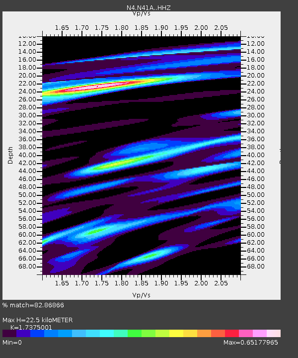
| Estimated Moho Depth: |
22.5 km |
| Estimated Crust Vp/Vs: |
1.74 |
| Assumed Crust Vp: |
6.498 km/s |
| Estimated Crust Vs: |
3.74 km/s |
| Estimated Crust Poisson's Ratio: |
0.25 |
|
| Radial Match: |
82.86866 % |
| Radial Bump: |
373 |
| Transverse Match: |
66.592255 % |
| Transverse Bump: |
400 |
| SOD ConfigId: |
13570011 |
| Insert Time: |
2019-04-28 04:40:05.238 +0000 |
| GWidth: |
2.5 |
| Max Bumps: |
400 |
| Tol: |
0.001 |
|

Signal To Noise
| Channel | StoN | STA | LTA |
| N4:N41A: :HHZ:20170612T12:40:28.599993Z | 12.080295 | 2.442772E-6 | 2.0221128E-7 |
| N4:N41A: :HHN:20170612T12:40:28.599993Z | 3.3140407 | 7.179978E-7 | 2.1665329E-7 |
| N4:N41A: :HHE:20170612T12:40:28.599993Z | 3.4432392 | 3.9263313E-7 | 1.1403016E-7 |
| Arrivals |
| Ps | 2.6 SECOND |
| PpPs | 9.2 SECOND |
| PsPs/PpSs | 12 SECOND |


