You are here: Home > Network List > N4 - Central and EAstern US Network Stations List
> Station Q54A Coxs Mills, WV, USA > Earthquake Result Viewer
Q54A Coxs Mills, WV, USA - Earthquake Result Viewer
| Earthquake location: |
Aegean Sea |
| Earthquake latitude/longitude: |
38.9/26.4 |
| Earthquake time(UTC): |
2017/06/12 (163) 12:28:38 GMT |
| Earthquake Depth: |
10 km |
| Earthquake Magnitude: |
6.3 Mww |
| Earthquake Catalog/Contributor: |
NEIC PDE/us |
|
| Network: |
N4 Central and EAstern US Network |
| Station: |
Q54A Coxs Mills, WV, USA |
| Lat/Lon: |
38.98 N/80.83 W |
| Elevation: |
254 m |
|
| Distance: |
77.7 deg |
| Az: |
310.366 deg |
| Baz: |
49.683 deg |
| Ray Param: |
0.050117917 |
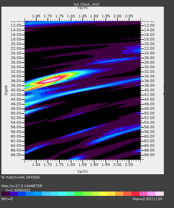
| Estimated Moho Depth: |
37.0 km |
| Estimated Crust Vp/Vs: |
1.69 |
| Assumed Crust Vp: |
6.207 km/s |
| Estimated Crust Vs: |
3.684 km/s |
| Estimated Crust Poisson's Ratio: |
0.23 |
|
| Radial Match: |
84.294586 % |
| Radial Bump: |
400 |
| Transverse Match: |
60.162094 % |
| Transverse Bump: |
399 |
| SOD ConfigId: |
13570011 |
| Insert Time: |
2019-04-28 04:40:21.443 +0000 |
| GWidth: |
2.5 |
| Max Bumps: |
400 |
| Tol: |
0.001 |
|

Signal To Noise
| Channel | StoN | STA | LTA |
| N4:Q54A: :HHZ:20170612T12:40:04.459978Z | 5.039826 | 1.6533661E-6 | 3.2806017E-7 |
| N4:Q54A: :HHN:20170612T12:40:04.459978Z | 2.2045124 | 4.2721842E-7 | 1.937927E-7 |
| N4:Q54A: :HHE:20170612T12:40:04.459978Z | 4.1364365 | 8.133896E-7 | 1.9664016E-7 |
| Arrivals |
| Ps | 4.2 SECOND |
| PpPs | 16 SECOND |
| PsPs/PpSs | 20 SECOND |


