You are here: Home > Network List > TA - USArray Transportable Network (new EarthScope stations) Stations List
> Station 113A Mohawk Valley, Roll, AZ, USA > Earthquake Result Viewer
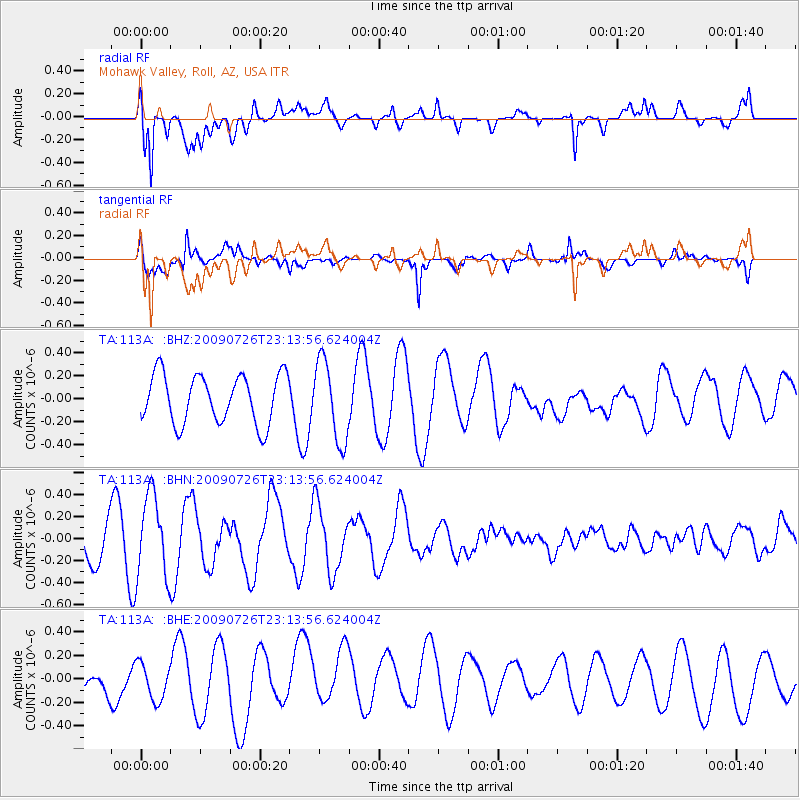
113A Mohawk Valley, Roll, AZ, USA - Earthquake Result Viewer
*The percent match for this event was below the threshold and hence no stack was calculated.
| Earthquake location: |
Vanuatu Islands |
| Earthquake latitude/longitude: |
-17.8/168.1 |
| Earthquake time(UTC): |
2009/07/26 (207) 23:01:31 GMT |
| Earthquake Depth: |
25 km |
| Earthquake Magnitude: |
5.8 MB, 5.9 MW, 5.7 MW |
| Earthquake Catalog/Contributor: |
WHDF/NEIC |
|
| Network: |
TA USArray Transportable Network (new EarthScope stations) |
| Station: |
113A Mohawk Valley, Roll, AZ, USA |
| Lat/Lon: |
32.77 N/113.77 W |
| Elevation: |
118 m |
|
| Distance: |
89.9 deg |
| Az: |
55.542 deg |
| Baz: |
248.849 deg |
| Ray Param: |
$rayparam |
*The percent match for this event was below the threshold and hence was not used in the summary stack. |
|
| Radial Match: |
83.43873 % |
| Radial Bump: |
400 |
| Transverse Match: |
81.29625 % |
| Transverse Bump: |
371 |
| SOD ConfigId: |
2622 |
| Insert Time: |
2010-03-06 00:45:09.079 +0000 |
| GWidth: |
2.5 |
| Max Bumps: |
400 |
| Tol: |
0.001 |
|
Signal To Noise
| Channel | StoN | STA | LTA |
| TA:113A: :BHN:20090726T23:13:56.624004Z | 2.023469 | 3.7639305E-7 | 1.8601375E-7 |
| TA:113A: :BHE:20090726T23:13:56.624004Z | 1.8820748 | 1.5384452E-7 | 8.174198E-8 |
| TA:113A: :BHZ:20090726T23:13:56.624004Z | 1.6576637 | 3.5005658E-7 | 2.1117465E-7 |
| Arrivals |
| Ps | |
| PpPs | |
| PsPs/PpSs | |


