You are here: Home > Network List > GS - US Geological Survey Networks Stations List
> Station KAN11 Stewart Ranch, Harper County, KS, USA > Earthquake Result Viewer
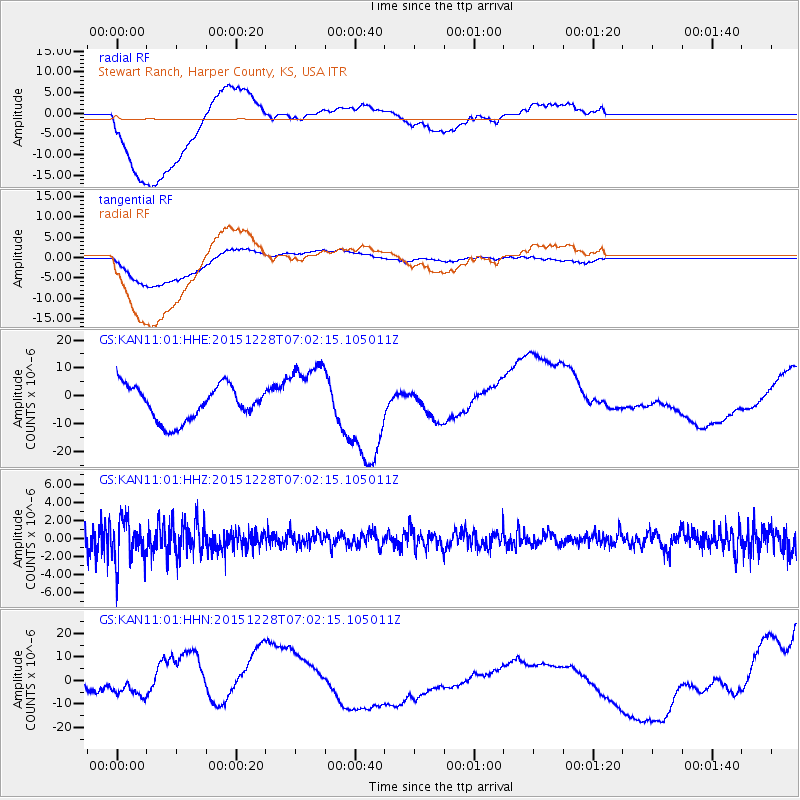
KAN11 Stewart Ranch, Harper County, KS, USA - Earthquake Result Viewer
*The percent match for this event was below the threshold and hence no stack was calculated.
| Earthquake location: |
Windward Islands |
| Earthquake latitude/longitude: |
14.6/-61.4 |
| Earthquake time(UTC): |
2015/12/28 (362) 06:55:30 GMT |
| Earthquake Depth: |
153 km |
| Earthquake Magnitude: |
5.6 MWP |
| Earthquake Catalog/Contributor: |
NEIC PDE/NEIC COMCAT |
|
| Network: |
GS US Geological Survey Networks |
| Station: |
KAN11 Stewart Ranch, Harper County, KS, USA |
| Lat/Lon: |
37.21 N/97.91 W |
| Elevation: |
410 m |
|
| Distance: |
39.5 deg |
| Az: |
311.617 deg |
| Baz: |
114.97 deg |
| Ray Param: |
$rayparam |
*The percent match for this event was below the threshold and hence was not used in the summary stack. |
|
| Radial Match: |
43.928955 % |
| Radial Bump: |
400 |
| Transverse Match: |
70.47021 % |
| Transverse Bump: |
400 |
| SOD ConfigId: |
1259291 |
| Insert Time: |
2016-01-11 07:29:45.692 +0000 |
| GWidth: |
2.5 |
| Max Bumps: |
400 |
| Tol: |
0.001 |
|
Signal To Noise
| Channel | StoN | STA | LTA |
| GS:KAN11:01:HHZ:20151228T07:02:15.105011Z | 2.032227 | 2.3412492E-6 | 1.1520608E-6 |
| GS:KAN11:01:HHN:20151228T07:02:15.105011Z | 0.908478 | 2.8083903E-6 | 3.0913134E-6 |
| GS:KAN11:01:HHE:20151228T07:02:15.105011Z | 1.9373685 | 1.192982E-5 | 6.1577443E-6 |
| Arrivals |
| Ps | |
| PpPs | |
| PsPs/PpSs | |


