You are here: Home > Network List > TA - USArray Transportable Network (new EarthScope stations) Stations List
> Station 113A Mohawk Valley, Roll, AZ, USA > Earthquake Result Viewer
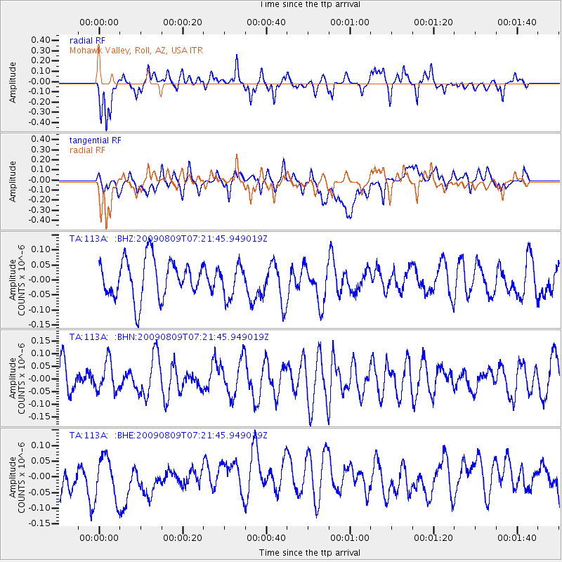
113A Mohawk Valley, Roll, AZ, USA - Earthquake Result Viewer
*The percent match for this event was below the threshold and hence no stack was calculated.
| Earthquake location: |
New Ireland Region, P.N.G. |
| Earthquake latitude/longitude: |
-4.6/153.2 |
| Earthquake time(UTC): |
2009/08/09 (221) 07:08:59 GMT |
| Earthquake Depth: |
49 km |
| Earthquake Magnitude: |
5.5 MW, 5.3 MB, 5.5 MW |
| Earthquake Catalog/Contributor: |
WHDF/NEIC |
|
| Network: |
TA USArray Transportable Network (new EarthScope stations) |
| Station: |
113A Mohawk Valley, Roll, AZ, USA |
| Lat/Lon: |
32.77 N/113.77 W |
| Elevation: |
118 m |
|
| Distance: |
95.0 deg |
| Az: |
57.627 deg |
| Baz: |
267.763 deg |
| Ray Param: |
$rayparam |
*The percent match for this event was below the threshold and hence was not used in the summary stack. |
|
| Radial Match: |
63.20703 % |
| Radial Bump: |
400 |
| Transverse Match: |
47.318127 % |
| Transverse Bump: |
400 |
| SOD ConfigId: |
2622 |
| Insert Time: |
2010-03-06 00:45:13.622 +0000 |
| GWidth: |
2.5 |
| Max Bumps: |
400 |
| Tol: |
0.001 |
|
Signal To Noise
| Channel | StoN | STA | LTA |
| TA:113A: :BHN:20090809T07:21:45.949019Z | 0.99207854 | 6.0680414E-8 | 6.1164926E-8 |
| TA:113A: :BHE:20090809T07:21:45.949019Z | 1.1366229 | 7.030245E-8 | 6.185204E-8 |
| TA:113A: :BHZ:20090809T07:21:45.949019Z | 0.83666074 | 5.3657264E-8 | 6.413264E-8 |
| Arrivals |
| Ps | |
| PpPs | |
| PsPs/PpSs | |


