You are here: Home > Network List > N4 - Central and EAstern US Network Stations List
> Station X58A Rowland, NC, USA > Earthquake Result Viewer
X58A Rowland, NC, USA - Earthquake Result Viewer
| Earthquake location: |
Aegean Sea |
| Earthquake latitude/longitude: |
38.9/26.4 |
| Earthquake time(UTC): |
2017/06/12 (163) 12:28:38 GMT |
| Earthquake Depth: |
10 km |
| Earthquake Magnitude: |
6.3 Mww |
| Earthquake Catalog/Contributor: |
NEIC PDE/us |
|
| Network: |
N4 Central and EAstern US Network |
| Station: |
X58A Rowland, NC, USA |
| Lat/Lon: |
34.55 N/79.34 W |
| Elevation: |
45 m |
|
| Distance: |
79.7 deg |
| Az: |
306.136 deg |
| Baz: |
49.746 deg |
| Ray Param: |
0.04879392 |
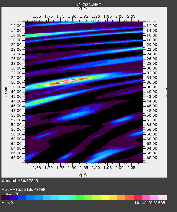
| Estimated Moho Depth: |
35.25 km |
| Estimated Crust Vp/Vs: |
1.78 |
| Assumed Crust Vp: |
6.565 km/s |
| Estimated Crust Vs: |
3.688 km/s |
| Estimated Crust Poisson's Ratio: |
0.27 |
|
| Radial Match: |
86.87845 % |
| Radial Bump: |
378 |
| Transverse Match: |
58.59977 % |
| Transverse Bump: |
400 |
| SOD ConfigId: |
13570011 |
| Insert Time: |
2019-04-28 04:40:48.337 +0000 |
| GWidth: |
2.5 |
| Max Bumps: |
400 |
| Tol: |
0.001 |
|

Signal To Noise
| Channel | StoN | STA | LTA |
| N4:X58A: :HHZ:20170612T12:40:15.110002Z | 9.08222 | 1.5169334E-6 | 1.670223E-7 |
| N4:X58A: :HHN:20170612T12:40:15.110002Z | 2.0730808 | 3.926954E-7 | 1.89426E-7 |
| N4:X58A: :HHE:20170612T12:40:15.110002Z | 3.2063744 | 6.1794117E-7 | 1.9272271E-7 |
| Arrivals |
| Ps | 4.3 SECOND |
| PpPs | 14 SECOND |
| PsPs/PpSs | 19 SECOND |


