You are here: Home > Network List > TA - USArray Transportable Network (new EarthScope stations) Stations List
> Station 113A Mohawk Valley, Roll, AZ, USA > Earthquake Result Viewer
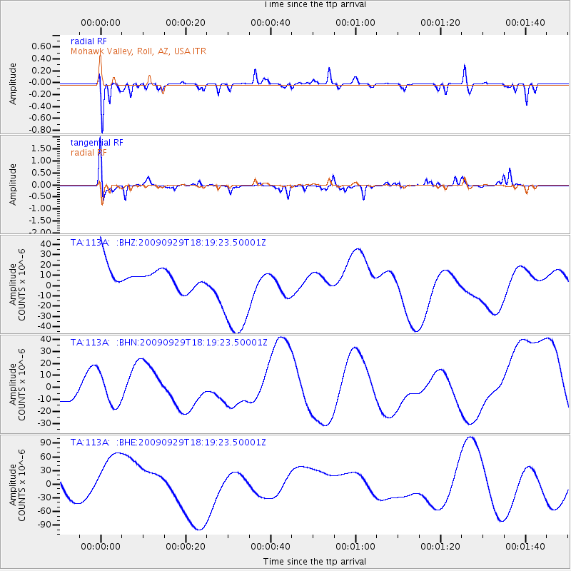
113A Mohawk Valley, Roll, AZ, USA - Earthquake Result Viewer
*The percent match for this event was below the threshold and hence no stack was calculated.
| Earthquake location: |
Samoa Islands Region |
| Earthquake latitude/longitude: |
-15.6/-172.0 |
| Earthquake time(UTC): |
2009/09/29 (272) 18:08:21 GMT |
| Earthquake Depth: |
10 km |
| Earthquake Magnitude: |
5.6 MB |
| Earthquake Catalog/Contributor: |
WHDF/NEIC |
|
| Network: |
TA USArray Transportable Network (new EarthScope stations) |
| Station: |
113A Mohawk Valley, Roll, AZ, USA |
| Lat/Lon: |
32.77 N/113.77 W |
| Elevation: |
118 m |
|
| Distance: |
73.5 deg |
| Az: |
48.342 deg |
| Baz: |
238.728 deg |
| Ray Param: |
$rayparam |
*The percent match for this event was below the threshold and hence was not used in the summary stack. |
|
| Radial Match: |
63.483494 % |
| Radial Bump: |
304 |
| Transverse Match: |
45.164177 % |
| Transverse Bump: |
345 |
| SOD ConfigId: |
2622 |
| Insert Time: |
2010-03-06 00:45:26.243 +0000 |
| GWidth: |
2.5 |
| Max Bumps: |
400 |
| Tol: |
0.001 |
|
Signal To Noise
| Channel | StoN | STA | LTA |
| TA:113A: :BHN:20090929T18:19:23.50001Z | 2.3808703 | 1.2723824E-5 | 5.3441895E-6 |
| TA:113A: :BHE:20090929T18:19:23.50001Z | 1.6080621 | 7.356325E-5 | 4.574652E-5 |
| TA:113A: :BHZ:20090929T18:19:23.50001Z | 4.536645 | 4.6879264E-5 | 1.0333465E-5 |
| Arrivals |
| Ps | |
| PpPs | |
| PsPs/PpSs | |


