You are here: Home > Network List > TA - USArray Transportable Network (new EarthScope stations) Stations List
> Station 113A Mohawk Valley, Roll, AZ, USA > Earthquake Result Viewer
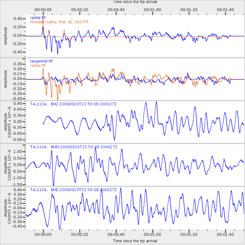
113A Mohawk Valley, Roll, AZ, USA - Earthquake Result Viewer
*The percent match for this event was below the threshold and hence no stack was calculated.
| Earthquake location: |
Samoa Islands Region |
| Earthquake latitude/longitude: |
-15.8/-172.6 |
| Earthquake time(UTC): |
2009/09/29 (272) 23:45:03 GMT |
| Earthquake Depth: |
10 km |
| Earthquake Magnitude: |
6.0 MB, 5.8 MS |
| Earthquake Catalog/Contributor: |
WHDF/NEIC |
|
| Network: |
TA USArray Transportable Network (new EarthScope stations) |
| Station: |
113A Mohawk Valley, Roll, AZ, USA |
| Lat/Lon: |
32.77 N/113.77 W |
| Elevation: |
118 m |
|
| Distance: |
74.1 deg |
| Az: |
48.527 deg |
| Baz: |
238.871 deg |
| Ray Param: |
$rayparam |
*The percent match for this event was below the threshold and hence was not used in the summary stack. |
|
| Radial Match: |
78.56163 % |
| Radial Bump: |
400 |
| Transverse Match: |
61.95446 % |
| Transverse Bump: |
382 |
| SOD ConfigId: |
2622 |
| Insert Time: |
2010-03-06 00:45:28.874 +0000 |
| GWidth: |
2.5 |
| Max Bumps: |
400 |
| Tol: |
0.001 |
|
Signal To Noise
| Channel | StoN | STA | LTA |
| TA:113A: :BHN:20090929T23:56:08.300027Z | 1.9563547 | 3.4001036E-7 | 1.7379791E-7 |
| TA:113A: :BHE:20090929T23:56:08.300027Z | 1.5134014 | 2.6792725E-7 | 1.7703648E-7 |
| TA:113A: :BHZ:20090929T23:56:08.300027Z | 1.0631309 | 2.4619055E-7 | 2.3157126E-7 |
| Arrivals |
| Ps | |
| PpPs | |
| PsPs/PpSs | |


