You are here: Home > Network List > NR - NARS Array Stations List
> Station NE219 Moremi > Earthquake Result Viewer
NE219 Moremi - Earthquake Result Viewer
| Earthquake location: |
Aegean Sea |
| Earthquake latitude/longitude: |
38.9/26.4 |
| Earthquake time(UTC): |
2017/06/12 (163) 12:28:38 GMT |
| Earthquake Depth: |
10 km |
| Earthquake Magnitude: |
6.3 Mww |
| Earthquake Catalog/Contributor: |
NEIC PDE/us |
|
| Network: |
NR NARS Array |
| Station: |
NE219 Moremi |
| Lat/Lon: |
22.57 S/27.45 E |
| Elevation: |
911 m |
|
| Distance: |
61.2 deg |
| Az: |
178.857 deg |
| Baz: |
359.036 deg |
| Ray Param: |
0.06103705 |
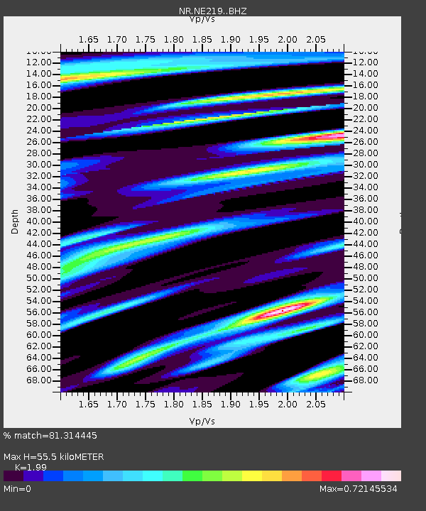
| Estimated Moho Depth: |
55.5 km |
| Estimated Crust Vp/Vs: |
1.99 |
| Assumed Crust Vp: |
6.459 km/s |
| Estimated Crust Vs: |
3.246 km/s |
| Estimated Crust Poisson's Ratio: |
0.33 |
|
| Radial Match: |
81.314445 % |
| Radial Bump: |
335 |
| Transverse Match: |
69.33852 % |
| Transverse Bump: |
400 |
| SOD ConfigId: |
13570011 |
| Insert Time: |
2019-04-28 04:41:37.307 +0000 |
| GWidth: |
2.5 |
| Max Bumps: |
400 |
| Tol: |
0.001 |
|

Signal To Noise
| Channel | StoN | STA | LTA |
| NR:NE219: :BHZ:20170612T12:38:22.294023Z | 9.011694 | 3.327703E-6 | 3.69265E-7 |
| NR:NE219: :BHN:20170612T12:38:22.294023Z | 4.700375 | 1.8499231E-6 | 3.9356928E-7 |
| NR:NE219: :BHE:20170612T12:38:22.294023Z | 0.8719237 | 4.83086E-7 | 5.540462E-7 |
| Arrivals |
| Ps | 8.9 SECOND |
| PpPs | 25 SECOND |
| PsPs/PpSs | 34 SECOND |


