You are here: Home > Network List > TA - USArray Transportable Network (new EarthScope stations) Stations List
> Station 113A Mohawk Valley, Roll, AZ, USA > Earthquake Result Viewer
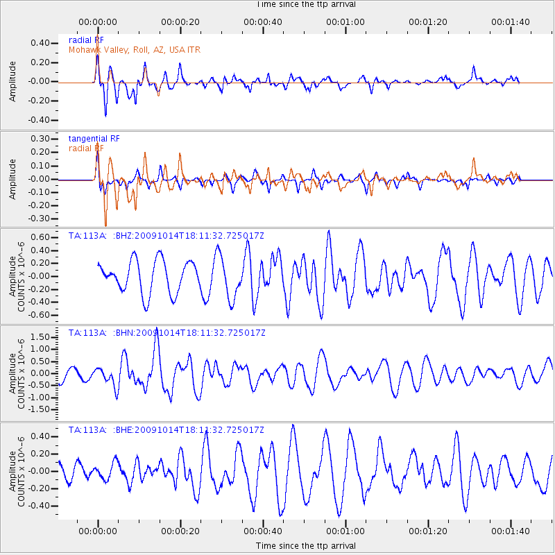
113A Mohawk Valley, Roll, AZ, USA - Earthquake Result Viewer
*The percent match for this event was below the threshold and hence no stack was calculated.
| Earthquake location: |
Samoa Islands Region |
| Earthquake latitude/longitude: |
-14.9/-174.8 |
| Earthquake time(UTC): |
2009/10/14 (287) 18:00:21 GMT |
| Earthquake Depth: |
10 km |
| Earthquake Magnitude: |
5.7 MB, 6.0 MS, 6.3 MW, 6.2 MW |
| Earthquake Catalog/Contributor: |
WHDF/NEIC |
|
| Network: |
TA USArray Transportable Network (new EarthScope stations) |
| Station: |
113A Mohawk Valley, Roll, AZ, USA |
| Lat/Lon: |
32.77 N/113.77 W |
| Elevation: |
118 m |
|
| Distance: |
75.1 deg |
| Az: |
49.711 deg |
| Baz: |
241.078 deg |
| Ray Param: |
$rayparam |
*The percent match for this event was below the threshold and hence was not used in the summary stack. |
|
| Radial Match: |
74.08427 % |
| Radial Bump: |
400 |
| Transverse Match: |
65.46352 % |
| Transverse Bump: |
379 |
| SOD ConfigId: |
2622 |
| Insert Time: |
2010-03-06 00:45:43.284 +0000 |
| GWidth: |
2.5 |
| Max Bumps: |
400 |
| Tol: |
0.001 |
|
Signal To Noise
| Channel | StoN | STA | LTA |
| TA:113A: :BHN:20091014T18:11:32.725017Z | 1.7512151 | 3.9505042E-7 | 2.2558646E-7 |
| TA:113A: :BHE:20091014T18:11:32.725017Z | 1.0757747 | 9.7086314E-8 | 9.0247816E-8 |
| TA:113A: :BHZ:20091014T18:11:32.725017Z | 1.3189217 | 3.206129E-7 | 2.4308716E-7 |
| Arrivals |
| Ps | |
| PpPs | |
| PsPs/PpSs | |


