You are here: Home > Network List > IU - Global Seismograph Network (GSN - IRIS/USGS) Stations List
> Station RSSD Black Hills, South Dakota, USA > Earthquake Result Viewer
RSSD Black Hills, South Dakota, USA - Earthquake Result Viewer
*The percent match for this event was below the threshold and hence no stack was calculated.
| Earthquake location: |
Windward Islands |
| Earthquake latitude/longitude: |
14.6/-61.4 |
| Earthquake time(UTC): |
2015/12/28 (362) 06:55:30 GMT |
| Earthquake Depth: |
153 km |
| Earthquake Magnitude: |
5.6 MWP |
| Earthquake Catalog/Contributor: |
NEIC PDE/NEIC COMCAT |
|
| Network: |
IU Global Seismograph Network (GSN - IRIS/USGS) |
| Station: |
RSSD Black Hills, South Dakota, USA |
| Lat/Lon: |
44.12 N/104.04 W |
| Elevation: |
2090 m |
|
| Distance: |
46.7 deg |
| Az: |
317.842 deg |
| Baz: |
115.545 deg |
| Ray Param: |
$rayparam |
*The percent match for this event was below the threshold and hence was not used in the summary stack. |
|
| Radial Match: |
71.80455 % |
| Radial Bump: |
400 |
| Transverse Match: |
63.705074 % |
| Transverse Bump: |
400 |
| SOD ConfigId: |
1259291 |
| Insert Time: |
2016-01-11 07:31:33.703 +0000 |
| GWidth: |
2.5 |
| Max Bumps: |
400 |
| Tol: |
0.001 |
|
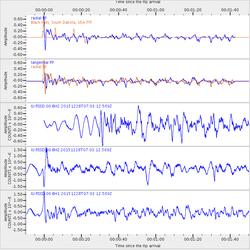
Signal To Noise
| Channel | StoN | STA | LTA |
| IU:RSSD:00:BHZ:20151228T07:03:12.569Z | 2.8135138 | 7.560805E-7 | 2.6873175E-7 |
| IU:RSSD:00:BH1:20151228T07:03:12.569Z | 3.71331 | 6.2823216E-7 | 1.6918388E-7 |
| IU:RSSD:00:BH2:20151228T07:03:12.569Z | 1.789 | 3.181955E-7 | 1.778622E-7 |
| Arrivals |
| Ps | |
| PpPs | |
| PsPs/PpSs | |


