You are here: Home > Network List > PR - Puerto Rico Seismic Network (PRSN) & Puerto Rico Strong Motion Program (PRSMP) Stations List
> Station OBIP Ponce, Puerto Rico(T4125) > Earthquake Result Viewer
OBIP Ponce, Puerto Rico(T4125) - Earthquake Result Viewer
| Earthquake location: |
Aegean Sea |
| Earthquake latitude/longitude: |
38.9/26.4 |
| Earthquake time(UTC): |
2017/06/12 (163) 12:28:38 GMT |
| Earthquake Depth: |
10 km |
| Earthquake Magnitude: |
6.3 Mww |
| Earthquake Catalog/Contributor: |
NEIC PDE/us |
|
| Network: |
PR Puerto Rico Seismic Network (PRSN) & Puerto Rico Strong Motion Program (PRSMP) |
| Station: |
OBIP Ponce, Puerto Rico(T4125) |
| Lat/Lon: |
18.04 N/66.61 W |
| Elevation: |
103 m |
|
| Distance: |
81.1 deg |
| Az: |
285.917 deg |
| Baz: |
52.03 deg |
| Ray Param: |
0.04780355 |
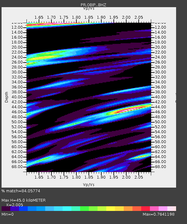
| Estimated Moho Depth: |
45.0 km |
| Estimated Crust Vp/Vs: |
2.01 |
| Assumed Crust Vp: |
5.14 km/s |
| Estimated Crust Vs: |
2.564 km/s |
| Estimated Crust Poisson's Ratio: |
0.33 |
|
| Radial Match: |
84.05774 % |
| Radial Bump: |
400 |
| Transverse Match: |
79.37973 % |
| Transverse Bump: |
400 |
| SOD ConfigId: |
13570011 |
| Insert Time: |
2019-04-28 04:42:47.690 +0000 |
| GWidth: |
2.5 |
| Max Bumps: |
400 |
| Tol: |
0.001 |
|

Signal To Noise
| Channel | StoN | STA | LTA |
| PR:OBIP: :BHZ:20170612T12:40:22.839983Z | 9.95796 | 1.9319075E-6 | 1.9400635E-7 |
| PR:OBIP: :BHN:20170612T12:40:22.839983Z | 1.461401 | 3.9931214E-7 | 2.7323927E-7 |
| PR:OBIP: :BHE:20170612T12:40:22.839983Z | 2.308809 | 5.7611885E-7 | 2.4953076E-7 |
| Arrivals |
| Ps | 8.9 SECOND |
| PpPs | 26 SECOND |
| PsPs/PpSs | 35 SECOND |


