You are here: Home > Network List > TA - USArray Transportable Network (new EarthScope stations) Stations List
> Station D23K Nanushuk River, AK USA > Earthquake Result Viewer
D23K Nanushuk River, AK USA - Earthquake Result Viewer
| Earthquake location: |
Aegean Sea |
| Earthquake latitude/longitude: |
38.9/26.4 |
| Earthquake time(UTC): |
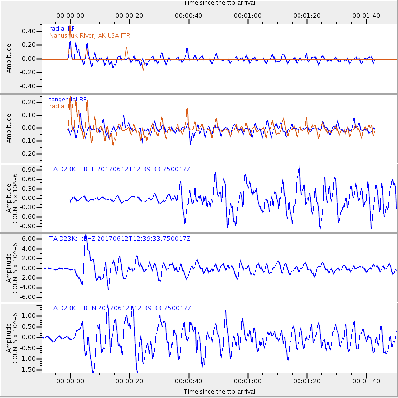
2017/06/12 (163) 12:28:38 GMT |
| Earthquake Depth: |
10 km |
| Earthquake Magnitude: |
6.3 Mww |
| Earthquake Catalog/Contributor: |
NEIC PDE/us |
|
| Network: |
TA USArray Transportable Network (new EarthScope stations) |
| Station: |
D23K Nanushuk River, AK USA |
| Lat/Lon: |
68.97 N/150.68 W |
| Elevation: |
406 m |
|
| Distance: |
72.4 deg |
| Az: |
358.881 deg |
| Baz: |
2.418 deg |
| Ray Param: |
0.053686492 |
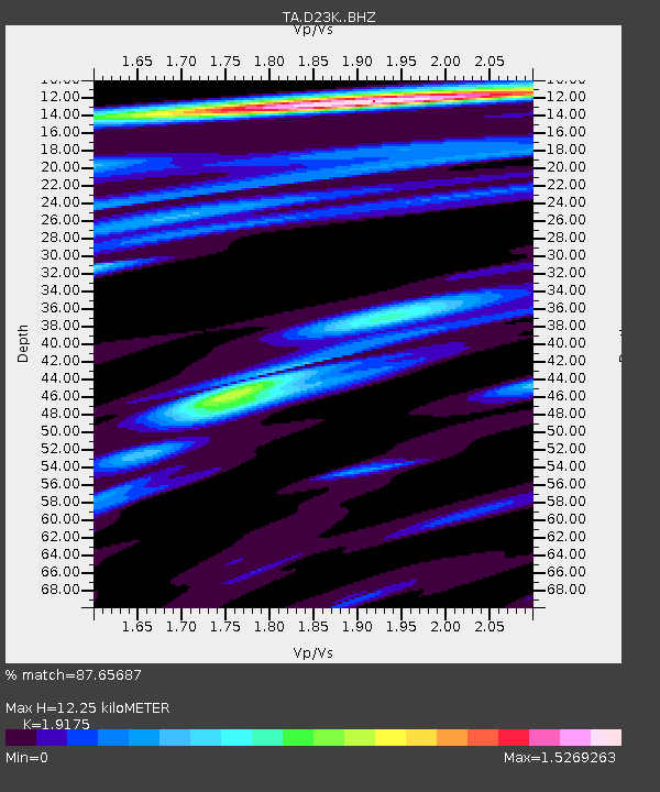
| Estimated Moho Depth: |
12.25 km |
| Estimated Crust Vp/Vs: |
1.92 |
| Assumed Crust Vp: |
6.221 km/s |
| Estimated Crust Vs: |
3.244 km/s |
| Estimated Crust Poisson's Ratio: |
0.31 |
|
| Radial Match: |
87.65687 % |
| Radial Bump: |
400 |
| Transverse Match: |
88.14115 % |
| Transverse Bump: |
400 |
| SOD ConfigId: |
13570011 |
| Insert Time: |
2019-04-28 04:43:12.847 +0000 |
| GWidth: |
2.5 |
| Max Bumps: |
400 |
| Tol: |
0.001 |
|
Signal To Noise
| Channel | StoN | STA | LTA |
| TA:D23K: :BHZ:20170612T12:39:33.750017Z | 16.84679 | 1.6884499E-6 | 1.0022383E-7 |
| TA:D23K: :BHN:20170612T12:39:33.750017Z | 4.42232 | 3.4906242E-7 | 7.893197E-8 |
| TA:D23K: :BHE:20170612T12:39:33.750017Z | 1.6235342 | 9.374915E-8 | 5.774387E-8 |
| Arrivals |
| Ps | 1.9 SECOND |
| PpPs | 5.6 SECOND |
| PsPs/PpSs | 7.4 SECOND |


