You are here: Home > Network List > TA - USArray Transportable Network (new EarthScope stations) Stations List
> Station E23K Chandalar, AK, USA > Earthquake Result Viewer
E23K Chandalar, AK, USA - Earthquake Result Viewer
| Earthquake location: |
Aegean Sea |
| Earthquake latitude/longitude: |
38.9/26.4 |
| Earthquake time(UTC): |
2017/06/12 (163) 12:28:38 GMT |
| Earthquake Depth: |
10 km |
| Earthquake Magnitude: |
6.3 Mww |
| Earthquake Catalog/Contributor: |
NEIC PDE/us |
|
| Network: |
TA USArray Transportable Network (new EarthScope stations) |
| Station: |
E23K Chandalar, AK, USA |
| Lat/Lon: |
68.06 N/149.62 W |
| Elevation: |
1084 m |
|
| Distance: |
73.3 deg |
| Az: |
358.424 deg |
| Baz: |
3.273 deg |
| Ray Param: |
0.053102225 |
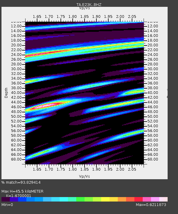
| Estimated Moho Depth: |
45.5 km |
| Estimated Crust Vp/Vs: |
1.67 |
| Assumed Crust Vp: |
6.316 km/s |
| Estimated Crust Vs: |
3.782 km/s |
| Estimated Crust Poisson's Ratio: |
0.22 |
|
| Radial Match: |
93.829414 % |
| Radial Bump: |
400 |
| Transverse Match: |
86.54604 % |
| Transverse Bump: |
400 |
| SOD ConfigId: |
13570011 |
| Insert Time: |
2019-04-28 04:43:17.236 +0000 |
| GWidth: |
2.5 |
| Max Bumps: |
400 |
| Tol: |
0.001 |
|

Signal To Noise
| Channel | StoN | STA | LTA |
| TA:E23K: :BHZ:20170612T12:39:39.02498Z | 27.742676 | 1.9147865E-6 | 6.9019535E-8 |
| TA:E23K: :BHN:20170612T12:39:39.02498Z | 14.90346 | 5.83076E-7 | 3.9123535E-8 |
| TA:E23K: :BHE:20170612T12:39:39.02498Z | 1.2227513 | 6.829356E-8 | 5.585237E-8 |
| Arrivals |
| Ps | 5.0 SECOND |
| PpPs | 19 SECOND |
| PsPs/PpSs | 24 SECOND |


