You are here: Home > Network List > TA - USArray Transportable Network (new EarthScope stations) Stations List
> Station G23K Bananza Creek, AK, USA > Earthquake Result Viewer
G23K Bananza Creek, AK, USA - Earthquake Result Viewer
| Earthquake location: |
Aegean Sea |
| Earthquake latitude/longitude: |
38.9/26.4 |
| Earthquake time(UTC): |
2017/06/12 (163) 12:28:38 GMT |
| Earthquake Depth: |
10 km |
| Earthquake Magnitude: |
6.3 Mww |
| Earthquake Catalog/Contributor: |
NEIC PDE/us |
|
| Network: |
TA USArray Transportable Network (new EarthScope stations) |
| Station: |
G23K Bananza Creek, AK, USA |
| Lat/Lon: |
66.71 N/150.02 W |
| Elevation: |
746 m |
|
| Distance: |
74.6 deg |
| Az: |
358.511 deg |
| Baz: |
2.921 deg |
| Ray Param: |
0.052191198 |
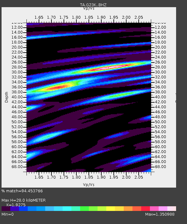
| Estimated Moho Depth: |
28.0 km |
| Estimated Crust Vp/Vs: |
1.93 |
| Assumed Crust Vp: |
6.577 km/s |
| Estimated Crust Vs: |
3.412 km/s |
| Estimated Crust Poisson's Ratio: |
0.32 |
|
| Radial Match: |
94.453766 % |
| Radial Bump: |
298 |
| Transverse Match: |
87.49269 % |
| Transverse Bump: |
400 |
| SOD ConfigId: |
13570011 |
| Insert Time: |
2019-04-28 04:43:26.788 +0000 |
| GWidth: |
2.5 |
| Max Bumps: |
400 |
| Tol: |
0.001 |
|
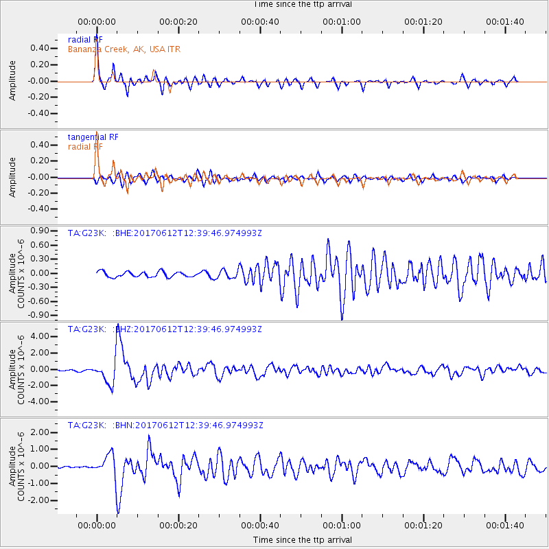
Signal To Noise
| Channel | StoN | STA | LTA |
| TA:G23K: :BHZ:20170612T12:39:46.974993Z | 23.295689 | 1.5184349E-6 | 6.518094E-8 |
| TA:G23K: :BHN:20170612T12:39:46.974993Z | 14.802533 | 6.773258E-7 | 4.5757425E-8 |
| TA:G23K: :BHE:20170612T12:39:46.974993Z | 1.5603269 | 8.9379014E-8 | 5.7282236E-8 |
| Arrivals |
| Ps | 4.1 SECOND |
| PpPs | 12 SECOND |
| PsPs/PpSs | 16 SECOND |


