You are here: Home > Network List > TA - USArray Transportable Network (new EarthScope stations) Stations List
> Station J29M Klondike Camp, Yukon, CA > Earthquake Result Viewer
J29M Klondike Camp, Yukon, CA - Earthquake Result Viewer
| Earthquake location: |
Aegean Sea |
| Earthquake latitude/longitude: |
38.9/26.4 |
| Earthquake time(UTC): |
2017/06/12 (163) 12:28:38 GMT |
| Earthquake Depth: |
10 km |
| Earthquake Magnitude: |
6.3 Mww |
| Earthquake Catalog/Contributor: |
NEIC PDE/us |
|
| Network: |
TA USArray Transportable Network (new EarthScope stations) |
| Station: |
J29M Klondike Camp, Yukon, CA |
| Lat/Lon: |
64.45 N/138.22 W |
| Elevation: |
982 m |
|
| Distance: |
76.2 deg |
| Az: |
353.182 deg |
| Baz: |
12.329 deg |
| Ray Param: |
0.05112935 |
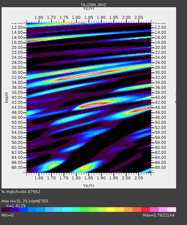
| Estimated Moho Depth: |
31.25 km |
| Estimated Crust Vp/Vs: |
1.81 |
| Assumed Crust Vp: |
6.566 km/s |
| Estimated Crust Vs: |
3.623 km/s |
| Estimated Crust Poisson's Ratio: |
0.28 |
|
| Radial Match: |
84.67552 % |
| Radial Bump: |
400 |
| Transverse Match: |
63.68933 % |
| Transverse Bump: |
400 |
| SOD ConfigId: |
13570011 |
| Insert Time: |
2019-04-28 04:43:48.402 +0000 |
| GWidth: |
2.5 |
| Max Bumps: |
400 |
| Tol: |
0.001 |
|

Signal To Noise
| Channel | StoN | STA | LTA |
| TA:J29M: :BHZ:20170612T12:39:56.050005Z | 6.3008003 | 1.8183806E-6 | 2.8859517E-7 |
| TA:J29M: :BHN:20170612T12:39:56.050005Z | 4.2241635 | 7.977117E-7 | 1.8884491E-7 |
| TA:J29M: :BHE:20170612T12:39:56.050005Z | 1.1620208 | 2.3660886E-7 | 2.0361843E-7 |
| Arrivals |
| Ps | 4.0 SECOND |
| PpPs | 13 SECOND |
| PsPs/PpSs | 17 SECOND |


