You are here: Home > Network List > TA - USArray Transportable Network (new EarthScope stations) Stations List
> Station L26K Log Cabin Wilderness Lodge, Tok, AK, USA > Earthquake Result Viewer
L26K Log Cabin Wilderness Lodge, Tok, AK, USA - Earthquake Result Viewer
| Earthquake location: |
Aegean Sea |
| Earthquake latitude/longitude: |
38.9/26.4 |
| Earthquake time(UTC): |
2017/06/12 (163) 12:28:38 GMT |
| Earthquake Depth: |
10 km |
| Earthquake Magnitude: |
6.3 Mww |
| Earthquake Catalog/Contributor: |
NEIC PDE/us |
|
| Network: |
TA USArray Transportable Network (new EarthScope stations) |
| Station: |
L26K Log Cabin Wilderness Lodge, Tok, AK, USA |
| Lat/Lon: |
63.03 N/143.35 W |
| Elevation: |
650 m |
|
| Distance: |
78.1 deg |
| Az: |
355.224 deg |
| Baz: |
8.186 deg |
| Ray Param: |
0.049903966 |
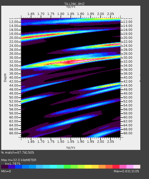
| Estimated Moho Depth: |
32.0 km |
| Estimated Crust Vp/Vs: |
1.80 |
| Assumed Crust Vp: |
6.566 km/s |
| Estimated Crust Vs: |
3.653 km/s |
| Estimated Crust Poisson's Ratio: |
0.28 |
|
| Radial Match: |
87.761505 % |
| Radial Bump: |
400 |
| Transverse Match: |
69.94294 % |
| Transverse Bump: |
400 |
| SOD ConfigId: |
13570011 |
| Insert Time: |
2019-04-28 04:44:02.631 +0000 |
| GWidth: |
2.5 |
| Max Bumps: |
400 |
| Tol: |
0.001 |
|

Signal To Noise
| Channel | StoN | STA | LTA |
| TA:L26K: :BHZ:20170612T12:40:06.224993Z | 34.77039 | 1.5181488E-6 | 4.3662112E-8 |
| TA:L26K: :BHN:20170612T12:40:06.224993Z | 3.233208 | 5.889544E-7 | 1.8215789E-7 |
| TA:L26K: :BHE:20170612T12:40:06.224993Z | 1.0181974 | 1.228563E-7 | 1.206606E-7 |
| Arrivals |
| Ps | 4.0 SECOND |
| PpPs | 13 SECOND |
| PsPs/PpSs | 17 SECOND |


