You are here: Home > Network List > TA - USArray Transportable Network (new EarthScope stations) Stations List
> Station M13K Dall Lake, AK, USA > Earthquake Result Viewer
M13K Dall Lake, AK, USA - Earthquake Result Viewer
| Earthquake location: |
Aegean Sea |
| Earthquake latitude/longitude: |
38.9/26.4 |
| Earthquake time(UTC): |
2017/06/12 (163) 12:28:38 GMT |
| Earthquake Depth: |
10 km |
| Earthquake Magnitude: |
6.3 Mww |
| Earthquake Catalog/Contributor: |
NEIC PDE/us |
|
| Network: |
TA USArray Transportable Network (new EarthScope stations) |
| Station: |
M13K Dall Lake, AK, USA |
| Lat/Lon: |
60.41 N/163.35 W |
| Elevation: |
9.0 m |
|
| Distance: |
80.7 deg |
| Az: |
4.867 deg |
| Baz: |
352.337 deg |
| Ray Param: |
0.04810744 |
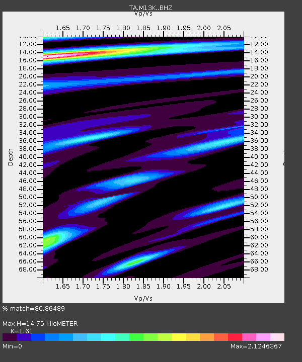
| Estimated Moho Depth: |
14.75 km |
| Estimated Crust Vp/Vs: |
1.61 |
| Assumed Crust Vp: |
6.1 km/s |
| Estimated Crust Vs: |
3.789 km/s |
| Estimated Crust Poisson's Ratio: |
0.19 |
|
| Radial Match: |
80.86489 % |
| Radial Bump: |
400 |
| Transverse Match: |
77.729 % |
| Transverse Bump: |
400 |
| SOD ConfigId: |
13570011 |
| Insert Time: |
2019-04-28 04:44:07.714 +0000 |
| GWidth: |
2.5 |
| Max Bumps: |
400 |
| Tol: |
0.001 |
|

Signal To Noise
| Channel | StoN | STA | LTA |
| TA:M13K: :BHZ:20170612T12:40:20.52498Z | 8.239925 | 2.164478E-6 | 2.6268174E-7 |
| TA:M13K: :BHN:20170612T12:40:20.52498Z | 2.4141338 | 5.888E-7 | 2.4389703E-7 |
| TA:M13K: :BHE:20170612T12:40:20.52498Z | 0.8335929 | 2.9685157E-7 | 3.5611095E-7 |
| Arrivals |
| Ps | 1.5 SECOND |
| PpPs | 6.1 SECOND |
| PsPs/PpSs | 7.7 SECOND |


