You are here: Home > Network List > TA - USArray Transportable Network (new EarthScope stations) Stations List
> Station N14K Kuskokwak Creek, AK, USA > Earthquake Result Viewer
N14K Kuskokwak Creek, AK, USA - Earthquake Result Viewer
| Earthquake location: |
Aegean Sea |
| Earthquake latitude/longitude: |
38.9/26.4 |
| Earthquake time(UTC): |
2017/06/12 (163) 12:28:38 GMT |
| Earthquake Depth: |
10 km |
| Earthquake Magnitude: |
6.3 Mww |
| Earthquake Catalog/Contributor: |
NEIC PDE/us |
|
| Network: |
TA USArray Transportable Network (new EarthScope stations) |
| Station: |
N14K Kuskokwak Creek, AK, USA |
| Lat/Lon: |
59.92 N/161.69 W |
| Elevation: |
21 m |
|
| Distance: |
81.3 deg |
| Az: |
4.091 deg |
| Baz: |
353.657 deg |
| Ray Param: |
0.04770038 |
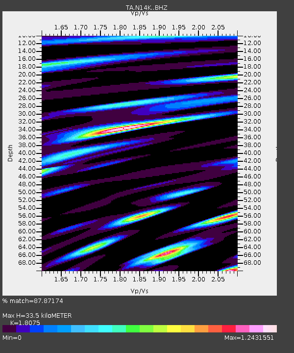
| Estimated Moho Depth: |
33.5 km |
| Estimated Crust Vp/Vs: |
1.81 |
| Assumed Crust Vp: |
6.24 km/s |
| Estimated Crust Vs: |
3.452 km/s |
| Estimated Crust Poisson's Ratio: |
0.28 |
|
| Radial Match: |
87.87174 % |
| Radial Bump: |
400 |
| Transverse Match: |
74.17523 % |
| Transverse Bump: |
400 |
| SOD ConfigId: |
13570011 |
| Insert Time: |
2019-04-28 04:44:24.875 +0000 |
| GWidth: |
2.5 |
| Max Bumps: |
400 |
| Tol: |
0.001 |
|

Signal To Noise
| Channel | StoN | STA | LTA |
| TA:N14K: :BHZ:20170612T12:40:23.64998Z | 28.06317 | 2.500105E-6 | 8.908847E-8 |
| TA:N14K: :BHN:20170612T12:40:23.64998Z | 4.102096 | 7.935403E-7 | 1.9344753E-7 |
| TA:N14K: :BHE:20170612T12:40:23.64998Z | 0.9810232 | 1.8361371E-7 | 1.8716551E-7 |
| Arrivals |
| Ps | 4.4 SECOND |
| PpPs | 15 SECOND |
| PsPs/PpSs | 19 SECOND |


