You are here: Home > Network List > TA - USArray Transportable Network (new EarthScope stations) Stations List
> Station N23A Red Feather Lakes, CO, USA > Earthquake Result Viewer
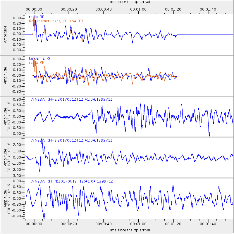
N23A Red Feather Lakes, CO, USA - Earthquake Result Viewer
*The percent match for this event was below the threshold and hence no stack was calculated.
| Earthquake location: |
Aegean Sea |
| Earthquake latitude/longitude: |
38.9/26.4 |
| Earthquake time(UTC): |
2017/06/12 (163) 12:28:38 GMT |
| Earthquake Depth: |
10 km |
| Earthquake Magnitude: |
6.3 Mww |
| Earthquake Catalog/Contributor: |
NEIC PDE/us |
|
| Network: |
TA USArray Transportable Network (new EarthScope stations) |
| Station: |
N23A Red Feather Lakes, CO, USA |
| Lat/Lon: |
40.89 N/105.94 W |
| Elevation: |
2458 m |
|
| Distance: |
89.4 deg |
| Az: |
325.898 deg |
| Baz: |
35.228 deg |
| Ray Param: |
$rayparam |
*The percent match for this event was below the threshold and hence was not used in the summary stack. |
|
| Radial Match: |
68.499245 % |
| Radial Bump: |
400 |
| Transverse Match: |
67.71662 % |
| Transverse Bump: |
400 |
| SOD ConfigId: |
13570011 |
| Insert Time: |
2019-04-28 04:44:30.200 +0000 |
| GWidth: |
2.5 |
| Max Bumps: |
400 |
| Tol: |
0.001 |
|
Signal To Noise
| Channel | StoN | STA | LTA |
| TA:N23A: :HHZ:20170612T12:41:04.139971Z | 10.0095625 | 1.3851102E-6 | 1.383787E-7 |
| TA:N23A: :HHN:20170612T12:41:04.139971Z | 1.9844289 | 4.0739977E-7 | 2.0529825E-7 |
| TA:N23A: :HHE:20170612T12:41:04.139971Z | 1.5296857 | 1.8156264E-7 | 1.18692775E-7 |
| Arrivals |
| Ps | |
| PpPs | |
| PsPs/PpSs | |


