You are here: Home > Network List > TA - USArray Transportable Network (new EarthScope stations) Stations List
> Station P52A Corning, OH, USA > Earthquake Result Viewer
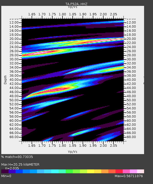
P52A Corning, OH, USA - Earthquake Result Viewer
| Earthquake location: |
Aegean Sea |
| Earthquake latitude/longitude: |
38.9/26.4 |
| Earthquake time(UTC): |
2017/06/12 (163) 12:28:38 GMT |
| Earthquake Depth: |
10 km |
| Earthquake Magnitude: |
6.3 Mww |
| Earthquake Catalog/Contributor: |
NEIC PDE/us |
|
| Network: |
TA USArray Transportable Network (new EarthScope stations) |
| Station: |
P52A Corning, OH, USA |
| Lat/Lon: |
39.63 N/82.13 W |
| Elevation: |
293 m |
|
| Distance: |
78.1 deg |
| Az: |
311.54 deg |
| Baz: |
49.11 deg |
| Ray Param: |
0.049884643 |
| Estimated Moho Depth: |
20.25 km |
| Estimated Crust Vp/Vs: |
2.04 |
| Assumed Crust Vp: |
6.232 km/s |
| Estimated Crust Vs: |
3.062 km/s |
| Estimated Crust Poisson's Ratio: |
0.34 |
|
| Radial Match: |
80.73035 % |
| Radial Bump: |
383 |
| Transverse Match: |
49.566402 % |
| Transverse Bump: |
400 |
| SOD ConfigId: |
13570011 |
| Insert Time: |
2019-04-28 04:44:51.335 +0000 |
| GWidth: |
2.5 |
| Max Bumps: |
400 |
| Tol: |
0.001 |
|

Signal To Noise
| Channel | StoN | STA | LTA |
| TA:P52A: :HHZ:20170612T12:40:06.360002Z | 10.355105 | 1.8368934E-6 | 1.7739012E-7 |
| TA:P52A: :HHN:20170612T12:40:06.360002Z | 2.2674656 | 3.874918E-7 | 1.7089204E-7 |
| TA:P52A: :HHE:20170612T12:40:06.360002Z | 4.327042 | 5.82362E-7 | 1.3458663E-7 |
| Arrivals |
| Ps | 3.4 SECOND |
| PpPs | 9.6 SECOND |
| PsPs/PpSs | 13 SECOND |


