You are here: Home > Network List > TA - USArray Transportable Network (new EarthScope stations) Stations List
> Station S32K Killisnoo, AK, USA > Earthquake Result Viewer
S32K Killisnoo, AK, USA - Earthquake Result Viewer
| Earthquake location: |
Aegean Sea |
| Earthquake latitude/longitude: |
38.9/26.4 |
| Earthquake time(UTC): |
2017/06/12 (163) 12:28:38 GMT |
| Earthquake Depth: |
10 km |
| Earthquake Magnitude: |
6.3 Mww |
| Earthquake Catalog/Contributor: |
NEIC PDE/us |
|
| Network: |
TA USArray Transportable Network (new EarthScope stations) |
| Station: |
S32K Killisnoo, AK, USA |
| Lat/Lon: |
57.47 N/134.58 W |
| Elevation: |
26 m |
|
| Distance: |
82.6 deg |
| Az: |
349.751 deg |
| Baz: |
14.882 deg |
| Ray Param: |
0.046754077 |
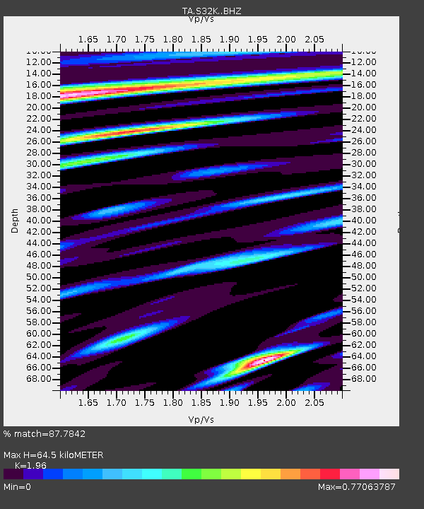
| Estimated Moho Depth: |
64.5 km |
| Estimated Crust Vp/Vs: |
1.96 |
| Assumed Crust Vp: |
6.472 km/s |
| Estimated Crust Vs: |
3.302 km/s |
| Estimated Crust Poisson's Ratio: |
0.32 |
|
| Radial Match: |
87.7842 % |
| Radial Bump: |
400 |
| Transverse Match: |
62.193504 % |
| Transverse Bump: |
400 |
| SOD ConfigId: |
13570011 |
| Insert Time: |
2019-04-28 04:45:04.359 +0000 |
| GWidth: |
2.5 |
| Max Bumps: |
400 |
| Tol: |
0.001 |
|

Signal To Noise
| Channel | StoN | STA | LTA |
| TA:S32K: :BHZ:20170612T12:40:30.750017Z | 6.2116446 | 1.6314585E-6 | 2.626452E-7 |
| TA:S32K: :BHN:20170612T12:40:30.750017Z | 2.1531334 | 4.838413E-7 | 2.2471495E-7 |
| TA:S32K: :BHE:20170612T12:40:30.750017Z | 1.4160553 | 2.6859945E-7 | 1.8968146E-7 |
| Arrivals |
| Ps | 9.8 SECOND |
| PpPs | 29 SECOND |
| PsPs/PpSs | 39 SECOND |


