You are here: Home > Network List > TJ - Tajikistan National Seismic Network Stations List
> Station GEZN Gezan, Tajikistan > Earthquake Result Viewer
GEZN Gezan, Tajikistan - Earthquake Result Viewer
| Earthquake location: |
Aegean Sea |
| Earthquake latitude/longitude: |
38.9/26.4 |
| Earthquake time(UTC): |
2017/06/12 (163) 12:28:38 GMT |
| Earthquake Depth: |
10 km |
| Earthquake Magnitude: |
6.3 Mww |
| Earthquake Catalog/Contributor: |
NEIC PDE/us |
|
| Network: |
TJ Tajikistan National Seismic Network |
| Station: |
GEZN Gezan, Tajikistan |
| Lat/Lon: |
39.28 N/67.72 E |
| Elevation: |
1485 m |
|
| Distance: |
31.9 deg |
| Az: |
76.065 deg |
| Baz: |
282.74 deg |
| Ray Param: |
0.078883626 |
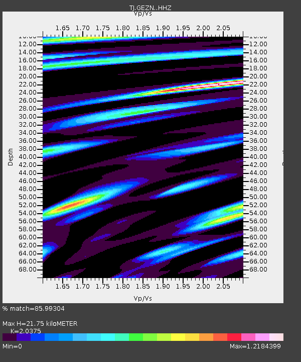
| Estimated Moho Depth: |
21.75 km |
| Estimated Crust Vp/Vs: |
2.04 |
| Assumed Crust Vp: |
6.444 km/s |
| Estimated Crust Vs: |
3.163 km/s |
| Estimated Crust Poisson's Ratio: |
0.34 |
|
| Radial Match: |
85.99304 % |
| Radial Bump: |
400 |
| Transverse Match: |
78.11687 % |
| Transverse Bump: |
400 |
| SOD ConfigId: |
13570011 |
| Insert Time: |
2019-04-28 04:45:24.246 +0000 |
| GWidth: |
2.5 |
| Max Bumps: |
400 |
| Tol: |
0.001 |
|
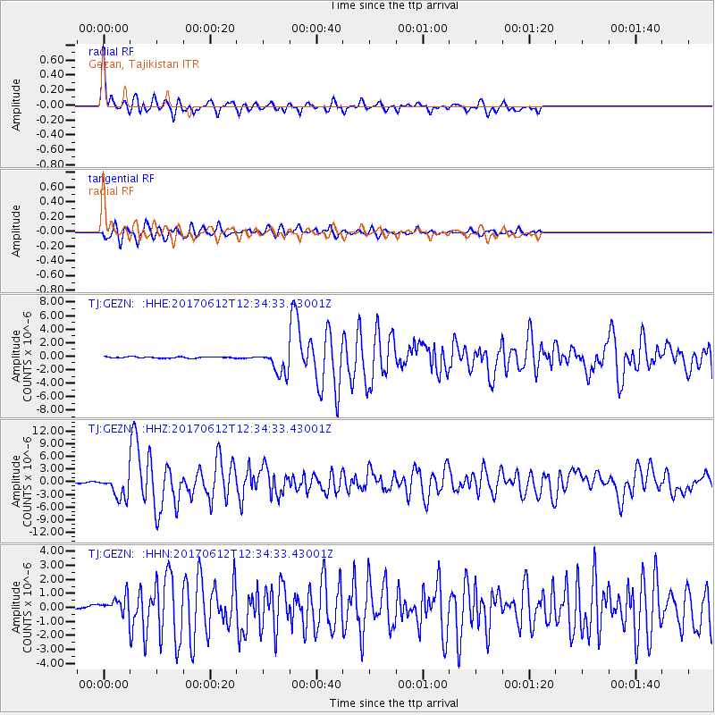
Signal To Noise
| Channel | StoN | STA | LTA |
| TJ:GEZN: :HHZ:20170612T12:34:33.43001Z | 25.30698 | 2.884244E-6 | 1.1397029E-7 |
| TJ:GEZN: :HHN:20170612T12:34:33.43001Z | 6.310828 | 7.5116225E-7 | 1.1902751E-7 |
| TJ:GEZN: :HHE:20170612T12:34:33.43001Z | 19.92089 | 1.8650076E-6 | 9.362069E-8 |
| Arrivals |
| Ps | 3.8 SECOND |
| PpPs | 9.6 SECOND |
| PsPs/PpSs | 13 SECOND |


