You are here: Home > Network List > UW - Pacific Northwest Regional Seismic Network Stations List
> Station HEBO Mt. Hebo, OR CREST BB SMO > Earthquake Result Viewer
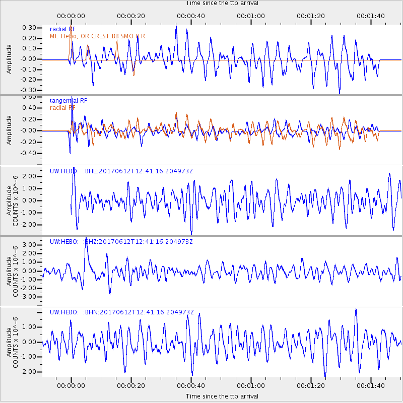
HEBO Mt. Hebo, OR CREST BB SMO - Earthquake Result Viewer
*The percent match for this event was below the threshold and hence no stack was calculated.
| Earthquake location: |
Aegean Sea |
| Earthquake latitude/longitude: |
38.9/26.4 |
| Earthquake time(UTC): |
2017/06/12 (163) 12:28:38 GMT |
| Earthquake Depth: |
10 km |
| Earthquake Magnitude: |
6.3 Mww |
| Earthquake Catalog/Contributor: |
NEIC PDE/us |
|
| Network: |
UW Pacific Northwest Regional Seismic Network |
| Station: |
HEBO Mt. Hebo, OR CREST BB SMO |
| Lat/Lon: |
45.21 N/123.76 W |
| Elevation: |
875 m |
|
| Distance: |
92.0 deg |
| Az: |
339.368 deg |
| Baz: |
22.881 deg |
| Ray Param: |
$rayparam |
*The percent match for this event was below the threshold and hence was not used in the summary stack. |
|
| Radial Match: |
66.48233 % |
| Radial Bump: |
400 |
| Transverse Match: |
55.20652 % |
| Transverse Bump: |
400 |
| SOD ConfigId: |
13570011 |
| Insert Time: |
2019-04-28 04:46:07.120 +0000 |
| GWidth: |
2.5 |
| Max Bumps: |
400 |
| Tol: |
0.001 |
|
Signal To Noise
| Channel | StoN | STA | LTA |
| UW:HEBO: :BHZ:20170612T12:41:16.204973Z | 2.2549603 | 1.1581973E-6 | 5.13622E-7 |
| UW:HEBO: :BHN:20170612T12:41:16.204973Z | 1.0410461 | 7.1512756E-7 | 6.869316E-7 |
| UW:HEBO: :BHE:20170612T12:41:16.204973Z | 0.78263146 | 6.251264E-7 | 7.987494E-7 |
| Arrivals |
| Ps | |
| PpPs | |
| PsPs/PpSs | |


