You are here: Home > Network List > UW - Pacific Northwest Regional Seismic Network Stations List
> Station OMAK Colville Reservation, Omak, WA, USA > Earthquake Result Viewer
OMAK Colville Reservation, Omak, WA, USA - Earthquake Result Viewer
| Earthquake location: |
Aegean Sea |
| Earthquake latitude/longitude: |
38.9/26.4 |
| Earthquake time(UTC): |
2017/06/12 (163) 12:28:38 GMT |
| Earthquake Depth: |
10 km |
| Earthquake Magnitude: |
6.3 Mww |
| Earthquake Catalog/Contributor: |
NEIC PDE/us |
|
| Network: |
UW Pacific Northwest Regional Seismic Network |
| Station: |
OMAK Colville Reservation, Omak, WA, USA |
| Lat/Lon: |
48.36 N/119.33 W |
| Elevation: |
696 m |
|
| Distance: |
87.9 deg |
| Az: |
337.906 deg |
| Baz: |
26.095 deg |
| Ray Param: |
0.042983916 |
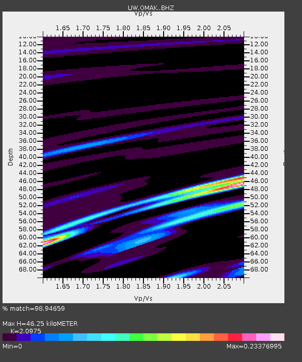
| Estimated Moho Depth: |
46.25 km |
| Estimated Crust Vp/Vs: |
2.10 |
| Assumed Crust Vp: |
6.419 km/s |
| Estimated Crust Vs: |
3.06 km/s |
| Estimated Crust Poisson's Ratio: |
0.35 |
|
| Radial Match: |
98.94659 % |
| Radial Bump: |
81 |
| Transverse Match: |
94.08387 % |
| Transverse Bump: |
333 |
| SOD ConfigId: |
13570011 |
| Insert Time: |
2019-04-28 04:46:11.801 +0000 |
| GWidth: |
2.5 |
| Max Bumps: |
400 |
| Tol: |
0.001 |
|
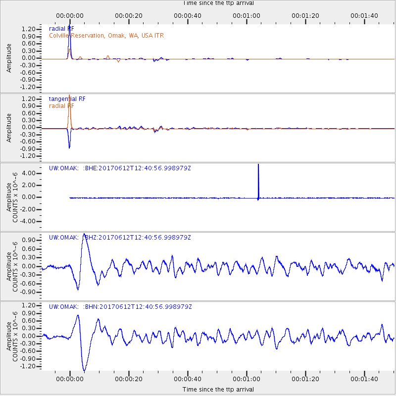
Signal To Noise
| Channel | StoN | STA | LTA |
| UW:OMAK: :BHZ:20170612T12:40:56.998979Z | 9.974594 | 5.3716536E-7 | 5.3853356E-8 |
| UW:OMAK: :BHN:20170612T12:40:56.998979Z | 10.234062 | 6.2180567E-7 | 6.075844E-8 |
| UW:OMAK: :BHE:20170612T12:40:56.998979Z | 1.1403065 | 1.9830223E-8 | 1.7390256E-8 |
| Arrivals |
| Ps | 8.1 SECOND |
| PpPs | 22 SECOND |
| PsPs/PpSs | 30 SECOND |


