You are here: Home > Network List > UW - Pacific Northwest Regional Seismic Network Stations List
> Station YACT Amboy, WA, USA > Earthquake Result Viewer
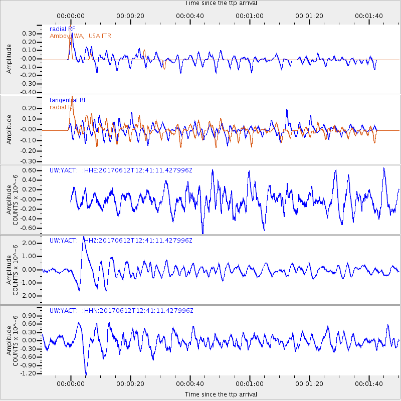
YACT Amboy, WA, USA - Earthquake Result Viewer
*The percent match for this event was below the threshold and hence no stack was calculated.
| Earthquake location: |
Aegean Sea |
| Earthquake latitude/longitude: |
38.9/26.4 |
| Earthquake time(UTC): |
2017/06/12 (163) 12:28:38 GMT |
| Earthquake Depth: |
10 km |
| Earthquake Magnitude: |
6.3 Mww |
| Earthquake Catalog/Contributor: |
NEIC PDE/us |
|
| Network: |
UW Pacific Northwest Regional Seismic Network |
| Station: |
YACT Amboy, WA, USA |
| Lat/Lon: |
45.93 N/122.42 W |
| Elevation: |
211 m |
|
| Distance: |
91.0 deg |
| Az: |
338.791 deg |
| Baz: |
23.847 deg |
| Ray Param: |
$rayparam |
*The percent match for this event was below the threshold and hence was not used in the summary stack. |
|
| Radial Match: |
74.89111 % |
| Radial Bump: |
400 |
| Transverse Match: |
76.510735 % |
| Transverse Bump: |
400 |
| SOD ConfigId: |
13570011 |
| Insert Time: |
2019-04-28 04:46:21.168 +0000 |
| GWidth: |
2.5 |
| Max Bumps: |
400 |
| Tol: |
0.001 |
|
Signal To Noise
| Channel | StoN | STA | LTA |
| UW:YACT: :HHZ:20170612T12:41:11.427996Z | 6.6829014 | 1.1622321E-6 | 1.739113E-7 |
| UW:YACT: :HHN:20170612T12:41:11.427996Z | 3.1359522 | 4.045203E-7 | 1.2899442E-7 |
| UW:YACT: :HHE:20170612T12:41:11.427996Z | 1.9043739 | 2.5278405E-7 | 1.3273866E-7 |
| Arrivals |
| Ps | |
| PpPs | |
| PsPs/PpSs | |


