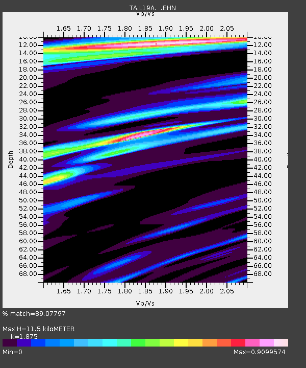
L19A Farson, WY, USA - Earthquake Result Viewer
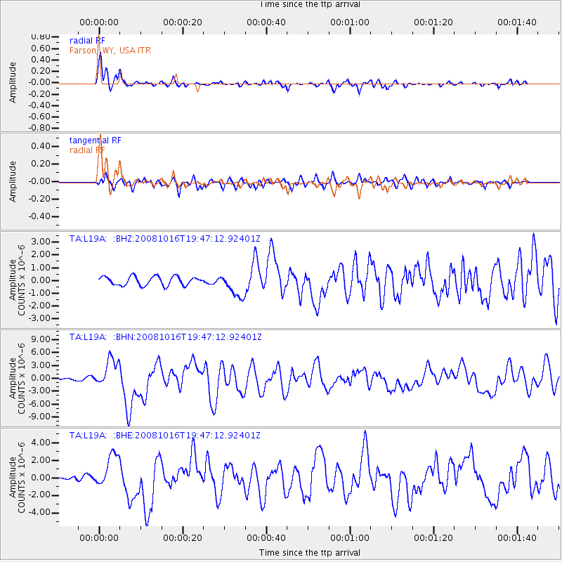
Earthquake location: Near Coast Of Chiapas, Mexico
Earthquake latitude/longitude: 14.4/-92.4
Earthquake time(UTC): 2008/10/16 (290) 19:41:25 GMT
Earthquake Depth: 24 km
Earthquake Magnitude: 6.1 MB, 6.6 MS, 6.7 MW, 6.6 MW
Earthquake Catalog/Contributor: WHDF/NEIC
Network: TA USArray Transportable Network (new EarthScope stations)
Station: L19A Farson, WY, USA
Lat/Lon: 42.10 N/109.36 W
Elevation: 2034 m
Distance: 31.3 deg
Az: 335.214 deg
Baz: 146.92 deg
Ray Param: 0.07910007
Estimated Moho Depth: 11.5 km
Estimated Crust Vp/Vs: 1.88
Assumed Crust Vp: 6.161 km/s
Estimated Crust Vs: 3.286 km/s
Estimated Crust Poisson's Ratio: 0.30
Radial Match: 89.07797 %
Radial Bump: 369
Transverse Match: 74.62456 %
Transverse Bump: 400
SOD ConfigId: 2556
Insert Time: 2010-03-06 00:47:38.071 +0000
GWidth: 2.5
Max Bumps: 400
Tol: 0.001

Signal To Noise

ChannelStoNSTALTA
TA:L19A: :BHN:20081016T19:47:12.92401Z10.3327683.4195762E-63.3094483E-7
TA:L19A: :BHE:20081016T19:47:12.92401Z3.5504371.9830693E-65.585423E-7
TA:L19A: :BHZ:20081016T19:47:12.92401Z2.75199999.4995244E-73.451862E-7
Arrivals
Ps1.7 SECOND
PpPs5.0 SECOND
PsPs/PpSs6.8 SECOND