You are here: Home > Network List > YO16 - Yukon Observatory Stations List
> Station LIRD YGS, Liard River Highway Maintenance Camp, BC > Earthquake Result Viewer
LIRD YGS, Liard River Highway Maintenance Camp, BC - Earthquake Result Viewer
| Earthquake location: |
Aegean Sea |
| Earthquake latitude/longitude: |
38.9/26.4 |
| Earthquake time(UTC): |
2017/06/12 (163) 12:28:38 GMT |
| Earthquake Depth: |
10 km |
| Earthquake Magnitude: |
6.3 Mww |
| Earthquake Catalog/Contributor: |
NEIC PDE/us |
|
| Network: |
YO Yukon Observatory |
| Station: |
LIRD YGS, Liard River Highway Maintenance Camp, BC |
| Lat/Lon: |
59.41 N/126.10 W |
| Elevation: |
439 m |
|
| Distance: |
79.4 deg |
| Az: |
346.08 deg |
| Baz: |
21.523 deg |
| Ray Param: |
0.048992336 |
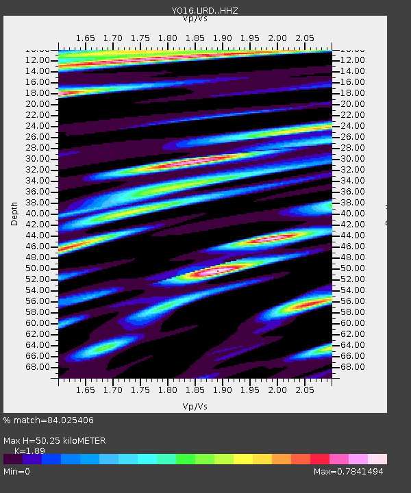
| Estimated Moho Depth: |
50.25 km |
| Estimated Crust Vp/Vs: |
1.89 |
| Assumed Crust Vp: |
6.419 km/s |
| Estimated Crust Vs: |
3.396 km/s |
| Estimated Crust Poisson's Ratio: |
0.31 |
|
| Radial Match: |
84.025406 % |
| Radial Bump: |
400 |
| Transverse Match: |
78.90739 % |
| Transverse Bump: |
400 |
| SOD ConfigId: |
13570011 |
| Insert Time: |
2019-04-28 04:47:18.524 +0000 |
| GWidth: |
2.5 |
| Max Bumps: |
400 |
| Tol: |
0.001 |
|

Signal To Noise
| Channel | StoN | STA | LTA |
| YO:LIRD: :HHZ:20170612T12:40:13.560015Z | 20.079845 | 1.9261095E-6 | 9.592253E-8 |
| YO:LIRD: :HHN:20170612T12:40:13.560015Z | 2.5502803 | 6.332813E-7 | 2.483183E-7 |
| YO:LIRD: :HHE:20170612T12:40:13.560015Z | 4.4781065 | 5.8614836E-7 | 1.3089202E-7 |
| Arrivals |
| Ps | 7.2 SECOND |
| PpPs | 22 SECOND |
| PsPs/PpSs | 29 SECOND |


