You are here: Home > Network List > TA - USArray Transportable Network (new EarthScope stations) Stations List
> Station L19A Farson, WY, USA > Earthquake Result Viewer
L19A Farson, WY, USA - Earthquake Result Viewer
| Earthquake location: |
Santa Cruz Islands Region |
| Earthquake latitude/longitude: |
-11.0/164.5 |
| Earthquake time(UTC): |
2008/07/19 (201) 09:27:01 GMT |
| Earthquake Depth: |
11 km |
| Earthquake Magnitude: |
6.1 MB, 6.4 MS, 6.6 MW, 6.6 MW |
| Earthquake Catalog/Contributor: |
WHDF/NEIC |
|
| Network: |
TA USArray Transportable Network (new EarthScope stations) |
| Station: |
L19A Farson, WY, USA |
| Lat/Lon: |
42.10 N/109.36 W |
| Elevation: |
2034 m |
|
| Distance: |
94.5 deg |
| Az: |
48.141 deg |
| Baz: |
259.269 deg |
| Ray Param: |
0.041034177 |
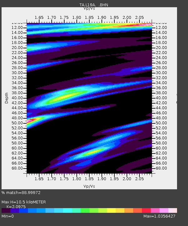
| Estimated Moho Depth: |
10.5 km |
| Estimated Crust Vp/Vs: |
2.10 |
| Assumed Crust Vp: |
6.161 km/s |
| Estimated Crust Vs: |
2.937 km/s |
| Estimated Crust Poisson's Ratio: |
0.35 |
|
| Radial Match: |
88.99972 % |
| Radial Bump: |
400 |
| Transverse Match: |
74.90072 % |
| Transverse Bump: |
400 |
| SOD ConfigId: |
2658 |
| Insert Time: |
2010-03-06 00:47:42.355 +0000 |
| GWidth: |
2.5 |
| Max Bumps: |
400 |
| Tol: |
0.001 |
|
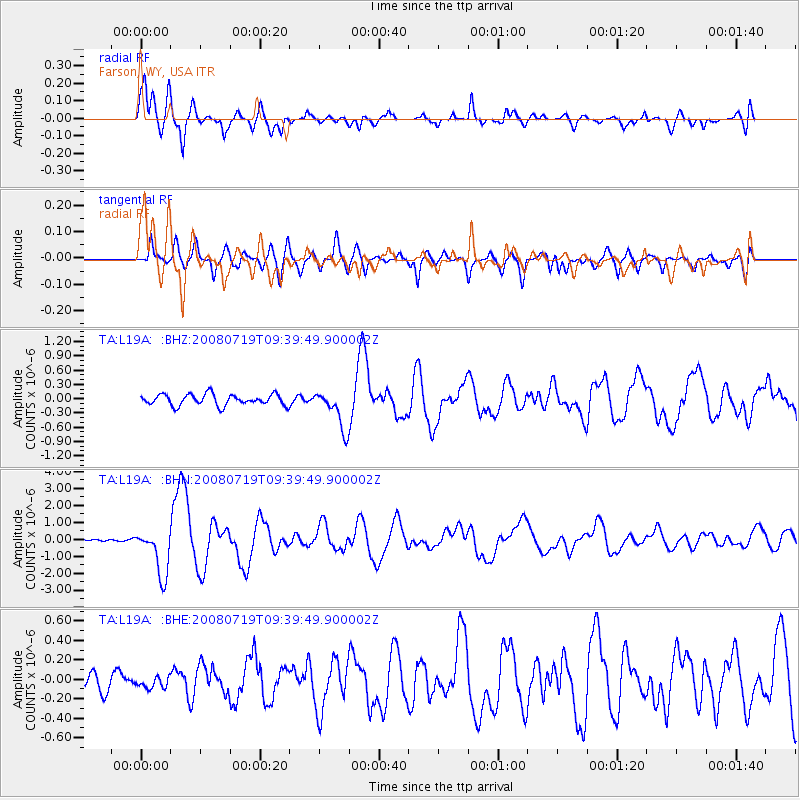
Signal To Noise
| Channel | StoN | STA | LTA |
| TA:L19A: :BHN:20080719T09:39:49.900002Z | 15.268121 | 1.4187916E-6 | 9.29251E-8 |
| TA:L19A: :BHE:20080719T09:39:49.900002Z | 0.6523286 | 5.9527505E-8 | 9.125386E-8 |
| TA:L19A: :BHZ:20080719T09:39:49.900002Z | 3.5137756 | 4.0714045E-7 | 1.1586979E-7 |
| Arrivals |
| Ps | 1.9 SECOND |
| PpPs | 5.2 SECOND |
| PsPs/PpSs | 7.1 SECOND |


