You are here: Home > Network List > TA - USArray Transportable Network (new EarthScope stations) Stations List
> Station L19A Farson, WY, USA > Earthquake Result Viewer
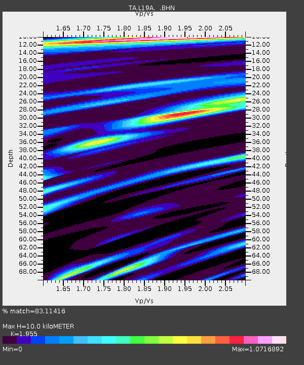
L19A Farson, WY, USA - Earthquake Result Viewer
| Earthquake location: |
Off Coast Of Costa Rica |
| Earthquake latitude/longitude: |
7.9/-85.6 |
| Earthquake time(UTC): |
2009/08/13 (225) 09:37:35 GMT |
| Earthquake Depth: |
10 km |
| Earthquake Magnitude: |
5.8 MW, 5.3 MB |
| Earthquake Catalog/Contributor: |
WHDF/NEIC |
|
| Network: |
TA USArray Transportable Network (new EarthScope stations) |
| Station: |
L19A Farson, WY, USA |
| Lat/Lon: |
42.10 N/109.36 W |
| Elevation: |
2034 m |
|
| Distance: |
40.0 deg |
| Az: |
332.206 deg |
| Baz: |
141.637 deg |
| Ray Param: |
0.07468105 |
| Estimated Moho Depth: |
10.0 km |
| Estimated Crust Vp/Vs: |
1.96 |
| Assumed Crust Vp: |
6.161 km/s |
| Estimated Crust Vs: |
3.151 km/s |
| Estimated Crust Poisson's Ratio: |
0.32 |
|
| Radial Match: |
83.11416 % |
| Radial Bump: |
400 |
| Transverse Match: |
68.31489 % |
| Transverse Bump: |
360 |
| SOD ConfigId: |
2622 |
| Insert Time: |
2010-03-06 00:47:59.186 +0000 |
| GWidth: |
2.5 |
| Max Bumps: |
400 |
| Tol: |
0.001 |
|

Signal To Noise
| Channel | StoN | STA | LTA |
| TA:L19A: :BHN:20090813T09:44:38.899011Z | 4.0414953 | 4.45488E-7 | 1.10228505E-7 |
| TA:L19A: :BHE:20090813T09:44:38.899011Z | 1.6042597 | 1.3035434E-7 | 8.125514E-8 |
| TA:L19A: :BHZ:20090813T09:44:38.899011Z | 1.9552515 | 1.2253919E-7 | 6.267184E-8 |
| Arrivals |
| Ps | 1.6 SECOND |
| PpPs | 4.5 SECOND |
| PsPs/PpSs | 6.2 SECOND |


