You are here: Home > Network List > TA - USArray Transportable Network (new EarthScope stations) Stations List
> Station L19A Farson, WY, USA > Earthquake Result Viewer
L19A Farson, WY, USA - Earthquake Result Viewer
| Earthquake location: |
Tonga Islands |
| Earthquake latitude/longitude: |
-16.3/-173.5 |
| Earthquake time(UTC): |
2009/10/02 (275) 01:07:39 GMT |
| Earthquake Depth: |
8.0 km |
| Earthquake Magnitude: |
6.1 MB, 6.0 MS, 6.1 MW, 6.1 MW |
| Earthquake Catalog/Contributor: |
WHDF/NEIC |
|
| Network: |
TA USArray Transportable Network (new EarthScope stations) |
| Station: |
L19A Farson, WY, USA |
| Lat/Lon: |
42.10 N/109.36 W |
| Elevation: |
2034 m |
|
| Distance: |
82.8 deg |
| Az: |
42.442 deg |
| Baz: |
240.535 deg |
| Ray Param: |
0.046636056 |
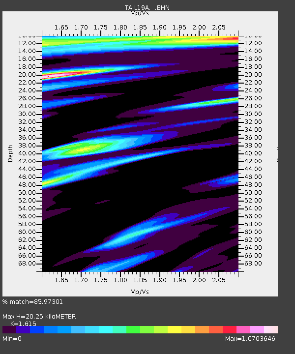
| Estimated Moho Depth: |
20.25 km |
| Estimated Crust Vp/Vs: |
1.62 |
| Assumed Crust Vp: |
6.161 km/s |
| Estimated Crust Vs: |
3.815 km/s |
| Estimated Crust Poisson's Ratio: |
0.19 |
|
| Radial Match: |
85.97301 % |
| Radial Bump: |
400 |
| Transverse Match: |
77.07511 % |
| Transverse Bump: |
400 |
| SOD ConfigId: |
2622 |
| Insert Time: |
2010-03-06 00:48:11.269 +0000 |
| GWidth: |
2.5 |
| Max Bumps: |
400 |
| Tol: |
0.001 |
|
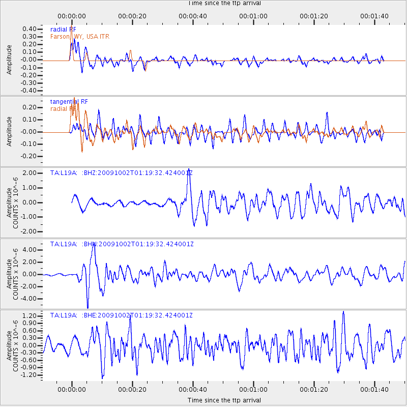
Signal To Noise
| Channel | StoN | STA | LTA |
| TA:L19A: :BHN:20091002T01:19:32.424001Z | 3.5204258 | 7.726875E-7 | 2.1948694E-7 |
| TA:L19A: :BHE:20091002T01:19:32.424001Z | 1.0988833 | 2.8036624E-7 | 2.5513742E-7 |
| TA:L19A: :BHZ:20091002T01:19:32.424001Z | 0.9141217 | 2.0177737E-7 | 2.2073358E-7 |
| Arrivals |
| Ps | 2.1 SECOND |
| PpPs | 8.4 SECOND |
| PsPs/PpSs | 10 SECOND |


