You are here: Home > Network List > TA - USArray Transportable Network (new EarthScope stations) Stations List
> Station L19A Farson, WY, USA > Earthquake Result Viewer
L19A Farson, WY, USA - Earthquake Result Viewer
| Earthquake location: |
North Of Svalbard |
| Earthquake latitude/longitude: |
80.3/-1.9 |
| Earthquake time(UTC): |
2009/03/06 (065) 10:50:29 GMT |
| Earthquake Depth: |
9.0 km |
| Earthquake Magnitude: |
6.6 MB, 6.5 MS, 6.5 MW, 6.4 MW |
| Earthquake Catalog/Contributor: |
WHDF/NEIC |
|
| Network: |
TA USArray Transportable Network (new EarthScope stations) |
| Station: |
L19A Farson, WY, USA |
| Lat/Lon: |
42.10 N/109.36 W |
| Elevation: |
2034 m |
|
| Distance: |
51.7 deg |
| Az: |
295.176 deg |
| Baz: |
11.872 deg |
| Ray Param: |
0.06727816 |
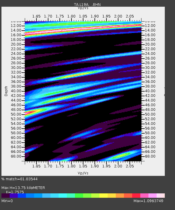
| Estimated Moho Depth: |
13.75 km |
| Estimated Crust Vp/Vs: |
1.76 |
| Assumed Crust Vp: |
6.161 km/s |
| Estimated Crust Vs: |
3.505 km/s |
| Estimated Crust Poisson's Ratio: |
0.26 |
|
| Radial Match: |
81.83544 % |
| Radial Bump: |
400 |
| Transverse Match: |
72.17196 % |
| Transverse Bump: |
400 |
| SOD ConfigId: |
2658 |
| Insert Time: |
2010-03-06 00:48:23.647 +0000 |
| GWidth: |
2.5 |
| Max Bumps: |
400 |
| Tol: |
0.001 |
|
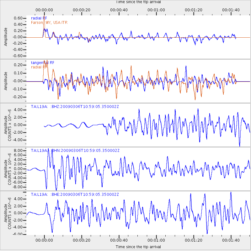
Signal To Noise
| Channel | StoN | STA | LTA |
| TA:L19A: :BHN:20090306T10:59:05.350002Z | 13.466935 | 5.0974513E-6 | 3.7851606E-7 |
| TA:L19A: :BHE:20090306T10:59:05.350002Z | 6.534379 | 2.2572772E-6 | 3.4544632E-7 |
| TA:L19A: :BHZ:20090306T10:59:05.350002Z | 2.1200626 | 8.0430755E-7 | 3.7937914E-7 |
| Arrivals |
| Ps | 1.8 SECOND |
| PpPs | 5.8 SECOND |
| PsPs/PpSs | 7.6 SECOND |


