You are here: Home > Network List > TA - USArray Transportable Network (new EarthScope stations) Stations List
> Station L19A Farson, WY, USA > Earthquake Result Viewer
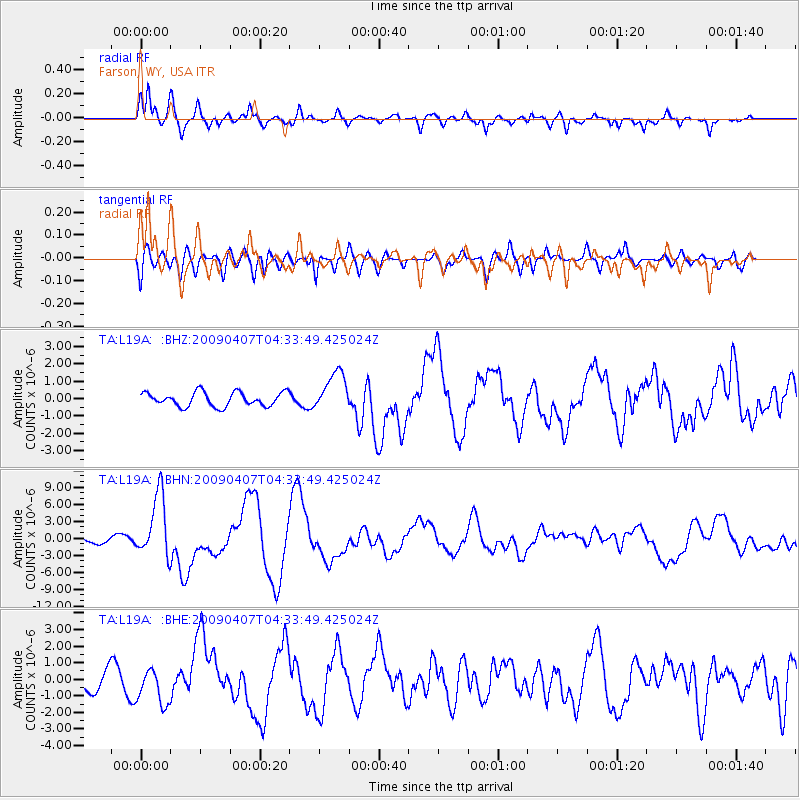
L19A Farson, WY, USA - Earthquake Result Viewer
*The percent match for this event was below the threshold and hence no stack was calculated.
| Earthquake location: |
Kuril Islands |
| Earthquake latitude/longitude: |
46.0/151.5 |
| Earthquake time(UTC): |
2009/04/07 (097) 04:23:33 GMT |
| Earthquake Depth: |
31 km |
| Earthquake Magnitude: |
6.5 MB, 6.8 MS, 6.9 MW, 6.9 MW |
| Earthquake Catalog/Contributor: |
WHDF/NEIC |
|
| Network: |
TA USArray Transportable Network (new EarthScope stations) |
| Station: |
L19A Farson, WY, USA |
| Lat/Lon: |
42.10 N/109.36 W |
| Elevation: |
2034 m |
|
| Distance: |
66.6 deg |
| Az: |
53.206 deg |
| Baz: |
311.46 deg |
| Ray Param: |
$rayparam |
*The percent match for this event was below the threshold and hence was not used in the summary stack. |
|
| Radial Match: |
83.51909 % |
| Radial Bump: |
400 |
| Transverse Match: |
67.72967 % |
| Transverse Bump: |
400 |
| SOD ConfigId: |
2658 |
| Insert Time: |
2010-03-06 00:48:38.933 +0000 |
| GWidth: |
2.5 |
| Max Bumps: |
400 |
| Tol: |
0.001 |
|
Signal To Noise
| Channel | StoN | STA | LTA |
| TA:L19A: :BHN:20090407T04:33:49.425024Z | 8.342386 | 5.5516016E-6 | 6.6546926E-7 |
| TA:L19A: :BHE:20090407T04:33:49.425024Z | 1.8336987 | 1.0915609E-6 | 5.952782E-7 |
| TA:L19A: :BHZ:20090407T04:33:49.425024Z | 2.8158734 | 1.1298013E-6 | 4.012259E-7 |
| Arrivals |
| Ps | |
| PpPs | |
| PsPs/PpSs | |


