You are here: Home > Network List > AK - Alaska Regional Network Stations List
> Station MCAR McCarthy VSAT, AK, USA > Earthquake Result Viewer
MCAR McCarthy VSAT, AK, USA - Earthquake Result Viewer
| Earthquake location: |
Near Coast Of Chiapas, Mexico |
| Earthquake latitude/longitude: |
14.2/-93.2 |
| Earthquake time(UTC): |
2017/06/14 (165) 06:38:48 GMT |
| Earthquake Depth: |
11 km |
| Earthquake Magnitude: |
5.5 Mww |
| Earthquake Catalog/Contributor: |
NEIC PDE/us |
|
| Network: |
AK Alaska Regional Network |
| Station: |
MCAR McCarthy VSAT, AK, USA |
| Lat/Lon: |
61.38 N/143.02 W |
| Elevation: |
447 m |
|
| Distance: |
59.0 deg |
| Az: |
334.57 deg |
| Baz: |
120.123 deg |
| Ray Param: |
0.062470198 |
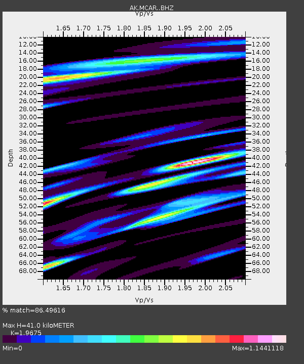
| Estimated Moho Depth: |
41.0 km |
| Estimated Crust Vp/Vs: |
1.97 |
| Assumed Crust Vp: |
6.566 km/s |
| Estimated Crust Vs: |
3.337 km/s |
| Estimated Crust Poisson's Ratio: |
0.33 |
|
| Radial Match: |
86.49616 % |
| Radial Bump: |
400 |
| Transverse Match: |
74.6134 % |
| Transverse Bump: |
400 |
| SOD ConfigId: |
13570011 |
| Insert Time: |
2019-04-28 04:52:40.731 +0000 |
| GWidth: |
2.5 |
| Max Bumps: |
400 |
| Tol: |
0.001 |
|

Signal To Noise
| Channel | StoN | STA | LTA |
| AK:MCAR: :BHZ:20170614T06:48:17.427981Z | 6.171587 | 4.349054E-7 | 7.046897E-8 |
| AK:MCAR: :BHN:20170614T06:48:17.427981Z | 2.3684103 | 1.7199591E-7 | 7.262082E-8 |
| AK:MCAR: :BHE:20170614T06:48:17.427981Z | 3.112282 | 2.374721E-7 | 7.6301596E-8 |
| Arrivals |
| Ps | 6.3 SECOND |
| PpPs | 18 SECOND |
| PsPs/PpSs | 24 SECOND |


