You are here: Home > Network List > US - United States National Seismic Network Stations List
> Station EGMT Eagleton, Montana, USA > Earthquake Result Viewer
EGMT Eagleton, Montana, USA - Earthquake Result Viewer
*The percent match for this event was below the threshold and hence no stack was calculated.
| Earthquake location: |
Windward Islands |
| Earthquake latitude/longitude: |
14.6/-61.4 |
| Earthquake time(UTC): |
2015/12/28 (362) 06:55:30 GMT |
| Earthquake Depth: |
153 km |
| Earthquake Magnitude: |
5.6 MWP |
| Earthquake Catalog/Contributor: |
NEIC PDE/NEIC COMCAT |
|
| Network: |
US United States National Seismic Network |
| Station: |
EGMT Eagleton, Montana, USA |
| Lat/Lon: |
48.02 N/109.75 W |
| Elevation: |
1055 m |
|
| Distance: |
51.9 deg |
| Az: |
320.367 deg |
| Baz: |
113.085 deg |
| Ray Param: |
$rayparam |
*The percent match for this event was below the threshold and hence was not used in the summary stack. |
|
| Radial Match: |
70.864716 % |
| Radial Bump: |
400 |
| Transverse Match: |
52.434853 % |
| Transverse Bump: |
327 |
| SOD ConfigId: |
1259291 |
| Insert Time: |
2016-01-11 07:37:02.533 +0000 |
| GWidth: |
2.5 |
| Max Bumps: |
400 |
| Tol: |
0.001 |
|
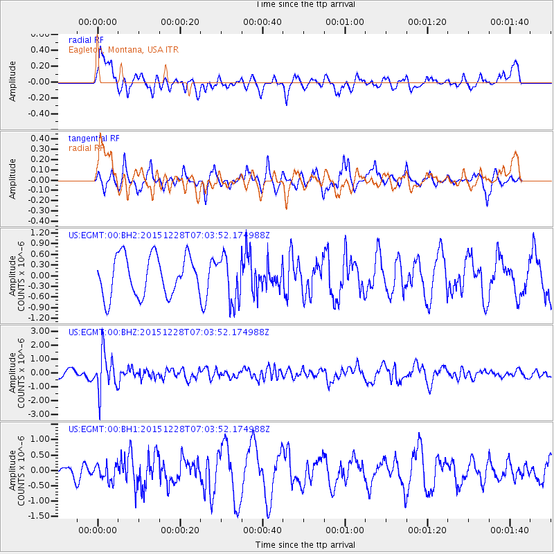
Signal To Noise
| Channel | StoN | STA | LTA |
| US:EGMT:00:BHZ:20151228T07:03:52.174988Z | 4.050162 | 1.4054342E-6 | 3.470069E-7 |
| US:EGMT:00:BH1:20151228T07:03:52.174988Z | 0.8193538 | 2.6306276E-7 | 3.2106126E-7 |
| US:EGMT:00:BH2:20151228T07:03:52.174988Z | 1.1684552 | 6.513128E-7 | 5.5741356E-7 |
| Arrivals |
| Ps | |
| PpPs | |
| PsPs/PpSs | |


