You are here: Home > Network List > TA - USArray Transportable Network (new EarthScope stations) Stations List
> Station L19A Farson, WY, USA > Earthquake Result Viewer
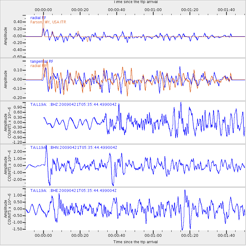
L19A Farson, WY, USA - Earthquake Result Viewer
*The percent match for this event was below the threshold and hence no stack was calculated.
| Earthquake location: |
Kuril Islands |
| Earthquake latitude/longitude: |
50.8/155.0 |
| Earthquake time(UTC): |
2009/04/21 (111) 05:26:11 GMT |
| Earthquake Depth: |
152 km |
| Earthquake Magnitude: |
6.0 MB, 6.2 MW, 6.2 MW |
| Earthquake Catalog/Contributor: |
WHDF/NEIC |
|
| Network: |
TA USArray Transportable Network (new EarthScope stations) |
| Station: |
L19A Farson, WY, USA |
| Lat/Lon: |
42.10 N/109.36 W |
| Elevation: |
2034 m |
|
| Distance: |
62.0 deg |
| Az: |
57.049 deg |
| Baz: |
314.355 deg |
| Ray Param: |
$rayparam |
*The percent match for this event was below the threshold and hence was not used in the summary stack. |
|
| Radial Match: |
75.66413 % |
| Radial Bump: |
400 |
| Transverse Match: |
71.50367 % |
| Transverse Bump: |
400 |
| SOD ConfigId: |
2760 |
| Insert Time: |
2010-03-06 00:49:02.898 +0000 |
| GWidth: |
2.5 |
| Max Bumps: |
400 |
| Tol: |
0.001 |
|
Signal To Noise
| Channel | StoN | STA | LTA |
| TA:L19A: :BHN:20090421T05:35:44.499004Z | 7.9253554 | 1.4966344E-6 | 1.8884128E-7 |
| TA:L19A: :BHE:20090421T05:35:44.499004Z | 3.166213 | 4.130952E-7 | 1.304698E-7 |
| TA:L19A: :BHZ:20090421T05:35:44.499004Z | 1.1375272 | 2.111887E-7 | 1.8565596E-7 |
| Arrivals |
| Ps | |
| PpPs | |
| PsPs/PpSs | |


