You are here: Home > Network List > TA - USArray Transportable Network (new EarthScope stations) Stations List
> Station L19A Farson, WY, USA > Earthquake Result Viewer
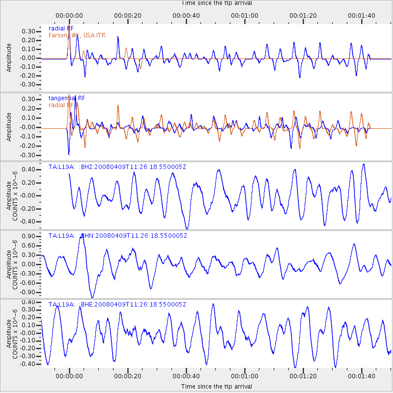
L19A Farson, WY, USA - Earthquake Result Viewer
*The percent match for this event was below the threshold and hence no stack was calculated.
| Earthquake location: |
Loyalty Islands |
| Earthquake latitude/longitude: |
-20.2/168.9 |
| Earthquake time(UTC): |
2008/04/09 (100) 11:13:17 GMT |
| Earthquake Depth: |
13 km |
| Earthquake Magnitude: |
5.6 MB, 6.3 MS, 6.4 MW, 6.3 MW |
| Earthquake Catalog/Contributor: |
WHDF/NEIC |
|
| Network: |
TA USArray Transportable Network (new EarthScope stations) |
| Station: |
L19A Farson, WY, USA |
| Lat/Lon: |
42.10 N/109.36 W |
| Elevation: |
2034 m |
|
| Distance: |
97.4 deg |
| Az: |
47.968 deg |
| Baz: |
249.65 deg |
| Ray Param: |
$rayparam |
*The percent match for this event was below the threshold and hence was not used in the summary stack. |
|
| Radial Match: |
65.32028 % |
| Radial Bump: |
400 |
| Transverse Match: |
59.604 % |
| Transverse Bump: |
400 |
| SOD ConfigId: |
2504 |
| Insert Time: |
2010-03-06 00:49:22.298 +0000 |
| GWidth: |
2.5 |
| Max Bumps: |
400 |
| Tol: |
0.001 |
|
Signal To Noise
| Channel | StoN | STA | LTA |
| TA:L19A: :BHN:20080409T11:26:18.550005Z | 2.9073565 | 5.2287714E-7 | 1.7984625E-7 |
| TA:L19A: :BHE:20080409T11:26:18.550005Z | 0.9706777 | 1.7769023E-7 | 1.830579E-7 |
| TA:L19A: :BHZ:20080409T11:26:18.550005Z | 1.2765368 | 2.0991602E-7 | 1.644418E-7 |
| Arrivals |
| Ps | |
| PpPs | |
| PsPs/PpSs | |


