You are here: Home > Network List > CI - Caltech Regional Seismic Network Stations List
> Station MPM Manuel Prospect Mine, California, USA > Earthquake Result Viewer
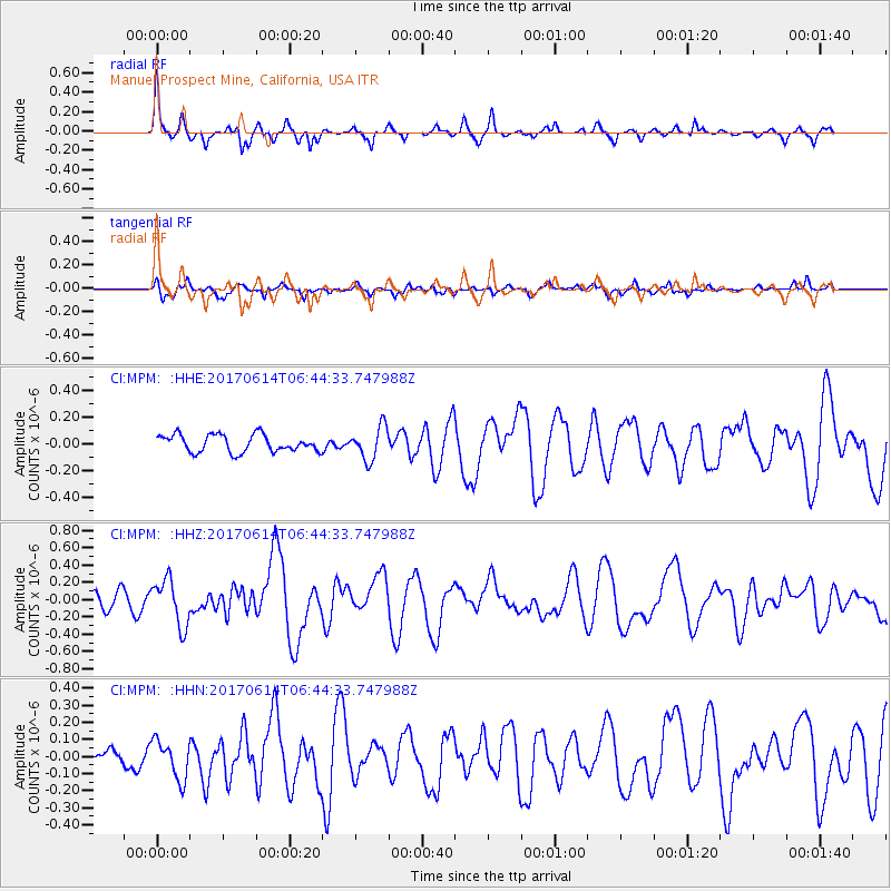
MPM Manuel Prospect Mine, California, USA - Earthquake Result Viewer
*The percent match for this event was below the threshold and hence no stack was calculated.
| Earthquake location: |
Near Coast Of Chiapas, Mexico |
| Earthquake latitude/longitude: |
14.2/-93.2 |
| Earthquake time(UTC): |
2017/06/14 (165) 06:38:48 GMT |
| Earthquake Depth: |
11 km |
| Earthquake Magnitude: |
5.5 Mww |
| Earthquake Catalog/Contributor: |
NEIC PDE/us |
|
| Network: |
CI Caltech Regional Seismic Network |
| Station: |
MPM Manuel Prospect Mine, California, USA |
| Lat/Lon: |
36.06 N/117.49 W |
| Elevation: |
185 m |
|
| Distance: |
30.8 deg |
| Az: |
319.283 deg |
| Baz: |
128.677 deg |
| Ray Param: |
$rayparam |
*The percent match for this event was below the threshold and hence was not used in the summary stack. |
|
| Radial Match: |
75.35208 % |
| Radial Bump: |
317 |
| Transverse Match: |
63.28379 % |
| Transverse Bump: |
400 |
| SOD ConfigId: |
13570011 |
| Insert Time: |
2019-04-28 04:54:20.753 +0000 |
| GWidth: |
2.5 |
| Max Bumps: |
400 |
| Tol: |
0.001 |
|
Signal To Noise
| Channel | StoN | STA | LTA |
| CI:MPM: :HHZ:20170614T06:44:33.747988Z | 2.425456 | 2.6698063E-7 | 1.1007441E-7 |
| CI:MPM: :HHN:20170614T06:44:33.747988Z | 2.0692306 | 1.1351735E-7 | 5.4859694E-8 |
| CI:MPM: :HHE:20170614T06:44:33.747988Z | 1.9214725 | 1.2321833E-7 | 6.412703E-8 |
| Arrivals |
| Ps | |
| PpPs | |
| PsPs/PpSs | |


