You are here: Home > Network List > TA - USArray Transportable Network (new EarthScope stations) Stations List
> Station L19A Farson, WY, USA > Earthquake Result Viewer
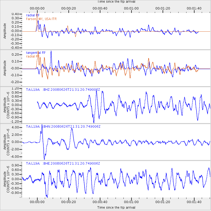
L19A Farson, WY, USA - Earthquake Result Viewer
*The percent match for this event was below the threshold and hence no stack was calculated.
| Earthquake location: |
Tonga Islands |
| Earthquake latitude/longitude: |
-20.8/-173.3 |
| Earthquake time(UTC): |
2008/06/26 (178) 21:19:15 GMT |
| Earthquake Depth: |
38 km |
| Earthquake Magnitude: |
6.0 MB, 5.8 MS, 6.2 MW, 6.1 MW |
| Earthquake Catalog/Contributor: |
WHDF/NEIC |
|
| Network: |
TA USArray Transportable Network (new EarthScope stations) |
| Station: |
L19A Farson, WY, USA |
| Lat/Lon: |
42.10 N/109.36 W |
| Elevation: |
2034 m |
|
| Distance: |
86.0 deg |
| Az: |
42.101 deg |
| Baz: |
237.464 deg |
| Ray Param: |
$rayparam |
*The percent match for this event was below the threshold and hence was not used in the summary stack. |
|
| Radial Match: |
78.13994 % |
| Radial Bump: |
400 |
| Transverse Match: |
81.707085 % |
| Transverse Bump: |
400 |
| SOD ConfigId: |
2504 |
| Insert Time: |
2010-03-06 00:49:37.968 +0000 |
| GWidth: |
2.5 |
| Max Bumps: |
400 |
| Tol: |
0.001 |
|
Signal To Noise
| Channel | StoN | STA | LTA |
| TA:L19A: :BHN:20080626T21:31:20.749006Z | 29.914717 | 2.2901595E-6 | 7.655628E-8 |
| TA:L19A: :BHE:20080626T21:31:20.749006Z | 1.1766756 | 1.9365001E-7 | 1.6457383E-7 |
| TA:L19A: :BHZ:20080626T21:31:20.749006Z | 2.7164032 | 3.0897542E-7 | 1.1374431E-7 |
| Arrivals |
| Ps | |
| PpPs | |
| PsPs/PpSs | |


