You are here: Home > Network List > CN - Canadian National Seismograph Network Stations List
> Station CLRS Cowichan Lake Research St, BC, CA > Earthquake Result Viewer
CLRS Cowichan Lake Research St, BC, CA - Earthquake Result Viewer
| Earthquake location: |
Near Coast Of Chiapas, Mexico |
| Earthquake latitude/longitude: |
14.2/-93.2 |
| Earthquake time(UTC): |
2017/06/14 (165) 06:38:48 GMT |
| Earthquake Depth: |
11 km |
| Earthquake Magnitude: |
5.5 Mww |
| Earthquake Catalog/Contributor: |
NEIC PDE/us |
|
| Network: |
CN Canadian National Seismograph Network |
| Station: |
CLRS Cowichan Lake Research St, BC, CA |
| Lat/Lon: |
48.82 N/124.13 W |
| Elevation: |
174 m |
|
| Distance: |
42.9 deg |
| Az: |
330.005 deg |
| Baz: |
132.819 deg |
| Ray Param: |
0.07290321 |
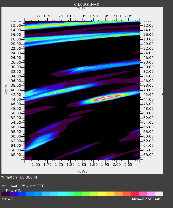
| Estimated Moho Depth: |
43.25 km |
| Estimated Crust Vp/Vs: |
1.95 |
| Assumed Crust Vp: |
6.391 km/s |
| Estimated Crust Vs: |
3.286 km/s |
| Estimated Crust Poisson's Ratio: |
0.32 |
|
| Radial Match: |
83.38074 % |
| Radial Bump: |
400 |
| Transverse Match: |
61.245678 % |
| Transverse Bump: |
400 |
| SOD ConfigId: |
13570011 |
| Insert Time: |
2019-04-28 04:54:34.161 +0000 |
| GWidth: |
2.5 |
| Max Bumps: |
400 |
| Tol: |
0.001 |
|

Signal To Noise
| Channel | StoN | STA | LTA |
| CN:CLRS: :HHZ:20170614T06:46:16.29999Z | 3.2285872 | 4.386224E-7 | 1.3585584E-7 |
| CN:CLRS: :HHN:20170614T06:46:16.29999Z | 1.5321336 | 2.0205434E-7 | 1.3187777E-7 |
| CN:CLRS: :HHE:20170614T06:46:16.29999Z | 3.2079341 | 3.2039094E-7 | 9.987454E-8 |
| Arrivals |
| Ps | 6.8 SECOND |
| PpPs | 19 SECOND |
| PsPs/PpSs | 26 SECOND |


