You are here: Home > Network List > TA - USArray Transportable Network (new EarthScope stations) Stations List
> Station L19A Farson, WY, USA > Earthquake Result Viewer
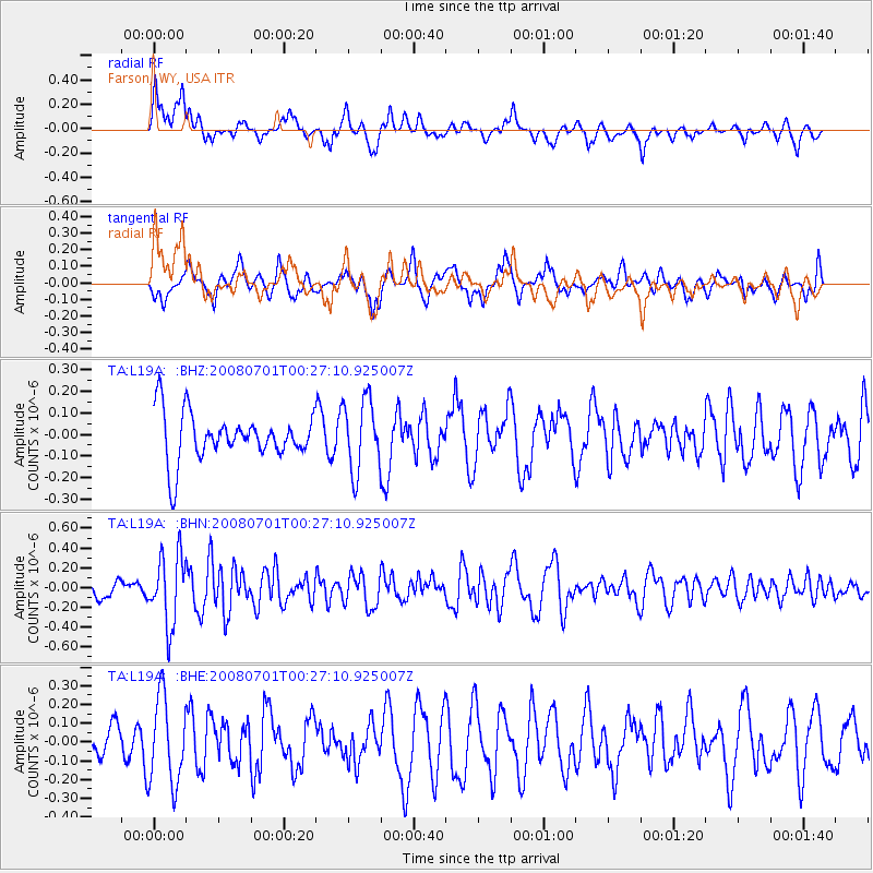
L19A Farson, WY, USA - Earthquake Result Viewer
*The percent match for this event was below the threshold and hence no stack was calculated.
| Earthquake location: |
Central Peru |
| Earthquake latitude/longitude: |
-10.4/-75.5 |
| Earthquake time(UTC): |
2008/07/01 (183) 00:17:33 GMT |
| Earthquake Depth: |
33 km |
| Earthquake Magnitude: |
5.5 MW, 5.0 MS, 5.4 MB, 5.3 ML |
| Earthquake Catalog/Contributor: |
WHDF/NEIC |
|
| Network: |
TA USArray Transportable Network (new EarthScope stations) |
| Station: |
L19A Farson, WY, USA |
| Lat/Lon: |
42.10 N/109.36 W |
| Elevation: |
2034 m |
|
| Distance: |
60.7 deg |
| Az: |
331.636 deg |
| Baz: |
141.091 deg |
| Ray Param: |
$rayparam |
*The percent match for this event was below the threshold and hence was not used in the summary stack. |
|
| Radial Match: |
57.553562 % |
| Radial Bump: |
400 |
| Transverse Match: |
60.144085 % |
| Transverse Bump: |
400 |
| SOD ConfigId: |
2504 |
| Insert Time: |
2010-03-06 00:49:38.978 +0000 |
| GWidth: |
2.5 |
| Max Bumps: |
400 |
| Tol: |
0.001 |
|
Signal To Noise
| Channel | StoN | STA | LTA |
| TA:L19A: :BHN:20080701T00:27:10.925007Z | 2.9060626 | 3.518572E-7 | 1.2107695E-7 |
| TA:L19A: :BHE:20080701T00:27:10.925007Z | 2.0153692 | 2.3112176E-7 | 1.1467962E-7 |
| TA:L19A: :BHZ:20080701T00:27:10.925007Z | 1.5154617 | 1.6615883E-7 | 1.0964238E-7 |
| Arrivals |
| Ps | |
| PpPs | |
| PsPs/PpSs | |


