You are here: Home > Network List > US - United States National Seismic Network Stations List
> Station MNTX Cornudas Mountains, Texas, USA > Earthquake Result Viewer
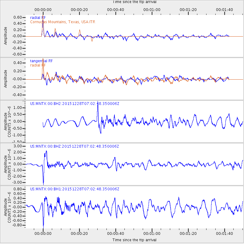
MNTX Cornudas Mountains, Texas, USA - Earthquake Result Viewer
*The percent match for this event was below the threshold and hence no stack was calculated.
| Earthquake location: |
Windward Islands |
| Earthquake latitude/longitude: |
14.6/-61.4 |
| Earthquake time(UTC): |
2015/12/28 (362) 06:55:30 GMT |
| Earthquake Depth: |
153 km |
| Earthquake Magnitude: |
5.6 MWP |
| Earthquake Catalog/Contributor: |
NEIC PDE/NEIC COMCAT |
|
| Network: |
US United States National Seismic Network |
| Station: |
MNTX Cornudas Mountains, Texas, USA |
| Lat/Lon: |
31.70 N/105.38 W |
| Elevation: |
404 m |
|
| Distance: |
43.6 deg |
| Az: |
300.779 deg |
| Baz: |
102.626 deg |
| Ray Param: |
$rayparam |
*The percent match for this event was below the threshold and hence was not used in the summary stack. |
|
| Radial Match: |
66.00201 % |
| Radial Bump: |
400 |
| Transverse Match: |
60.21571 % |
| Transverse Bump: |
400 |
| SOD ConfigId: |
1259291 |
| Insert Time: |
2016-01-11 07:38:04.308 +0000 |
| GWidth: |
2.5 |
| Max Bumps: |
400 |
| Tol: |
0.001 |
|
Signal To Noise
| Channel | StoN | STA | LTA |
| US:MNTX:00:BHZ:20151228T07:02:48.350006Z | 6.649109 | 1.2568081E-6 | 1.8901903E-7 |
| US:MNTX:00:BH1:20151228T07:02:48.350006Z | 2.0600698 | 3.3144732E-7 | 1.6089132E-7 |
| US:MNTX:00:BH2:20151228T07:02:48.350006Z | 2.5988612 | 4.796829E-7 | 1.8457426E-7 |
| Arrivals |
| Ps | |
| PpPs | |
| PsPs/PpSs | |


