You are here: Home > Network List > TA - USArray Transportable Network (new EarthScope stations) Stations List
> Station L19A Farson, WY, USA > Earthquake Result Viewer
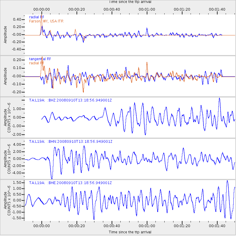
L19A Farson, WY, USA - Earthquake Result Viewer
*The percent match for this event was below the threshold and hence no stack was calculated.
| Earthquake location: |
Central Mid-Atlantic Ridge |
| Earthquake latitude/longitude: |
8.1/-38.7 |
| Earthquake time(UTC): |
2008/09/10 (254) 13:08:14 GMT |
| Earthquake Depth: |
10 km |
| Earthquake Magnitude: |
6.3 MB, 6.5 MS, 6.6 MW, 6.6 MW |
| Earthquake Catalog/Contributor: |
WHDF/NEIC |
|
| Network: |
TA USArray Transportable Network (new EarthScope stations) |
| Station: |
L19A Farson, WY, USA |
| Lat/Lon: |
42.10 N/109.36 W |
| Elevation: |
2034 m |
|
| Distance: |
70.3 deg |
| Az: |
311.761 deg |
| Baz: |
97.03 deg |
| Ray Param: |
$rayparam |
*The percent match for this event was below the threshold and hence was not used in the summary stack. |
|
| Radial Match: |
79.76816 % |
| Radial Bump: |
386 |
| Transverse Match: |
74.82931 % |
| Transverse Bump: |
400 |
| SOD ConfigId: |
2560 |
| Insert Time: |
2010-03-06 00:49:51.310 +0000 |
| GWidth: |
2.5 |
| Max Bumps: |
400 |
| Tol: |
0.001 |
|
Signal To Noise
| Channel | StoN | STA | LTA |
| TA:L19A: :BHN:20080910T13:18:56.949001Z | 1.9158996 | 4.3674598E-7 | 2.279587E-7 |
| TA:L19A: :BHE:20080910T13:18:56.949001Z | 0.668568 | 1.7983616E-7 | 2.689871E-7 |
| TA:L19A: :BHZ:20080910T13:18:56.949001Z | 0.56888187 | 1.2915177E-7 | 2.270274E-7 |
| Arrivals |
| Ps | |
| PpPs | |
| PsPs/PpSs | |


