You are here: Home > Network List > TA - USArray Transportable Network (new EarthScope stations) Stations List
> Station L19A Farson, WY, USA > Earthquake Result Viewer
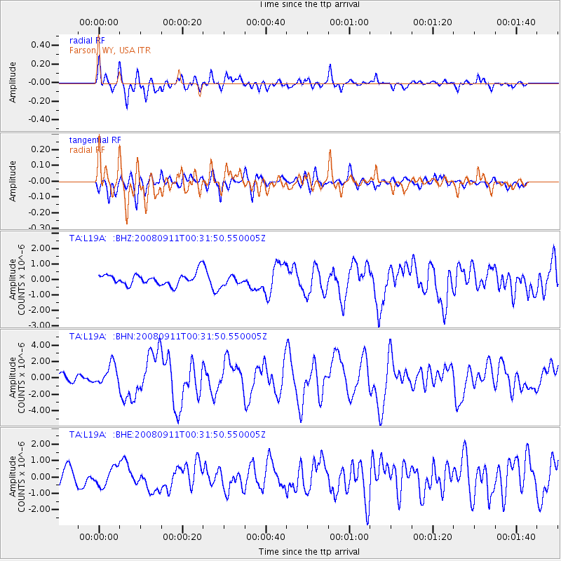
L19A Farson, WY, USA - Earthquake Result Viewer
*The percent match for this event was below the threshold and hence no stack was calculated.
| Earthquake location: |
Hokkaido, Japan Region |
| Earthquake latitude/longitude: |
41.9/143.8 |
| Earthquake time(UTC): |
2008/09/11 (255) 00:20:50 GMT |
| Earthquake Depth: |
25 km |
| Earthquake Magnitude: |
6.1 MB, 7.0 MS, 6.8 MW, 6.8 MW |
| Earthquake Catalog/Contributor: |
WHDF/NEIC |
|
| Network: |
TA USArray Transportable Network (new EarthScope stations) |
| Station: |
L19A Farson, WY, USA |
| Lat/Lon: |
42.10 N/109.36 W |
| Elevation: |
2034 m |
|
| Distance: |
73.6 deg |
| Az: |
47.94 deg |
| Baz: |
311.853 deg |
| Ray Param: |
$rayparam |
*The percent match for this event was below the threshold and hence was not used in the summary stack. |
|
| Radial Match: |
78.56494 % |
| Radial Bump: |
400 |
| Transverse Match: |
76.6069 % |
| Transverse Bump: |
400 |
| SOD ConfigId: |
2560 |
| Insert Time: |
2010-03-06 00:49:52.346 +0000 |
| GWidth: |
2.5 |
| Max Bumps: |
400 |
| Tol: |
0.001 |
|
Signal To Noise
| Channel | StoN | STA | LTA |
| TA:L19A: :BHN:20080911T00:31:50.550005Z | 2.7196298 | 1.3092435E-6 | 4.8140504E-7 |
| TA:L19A: :BHE:20080911T00:31:50.550005Z | 1.3467764 | 5.778684E-7 | 4.2907524E-7 |
| TA:L19A: :BHZ:20080911T00:31:50.550005Z | 0.7545673 | 2.816644E-7 | 3.7327933E-7 |
| Arrivals |
| Ps | |
| PpPs | |
| PsPs/PpSs | |


