You are here: Home > Network List > US - United States National Seismic Network Stations List
> Station WMOK Wichita Mountains, Oklahoma, USA > Earthquake Result Viewer
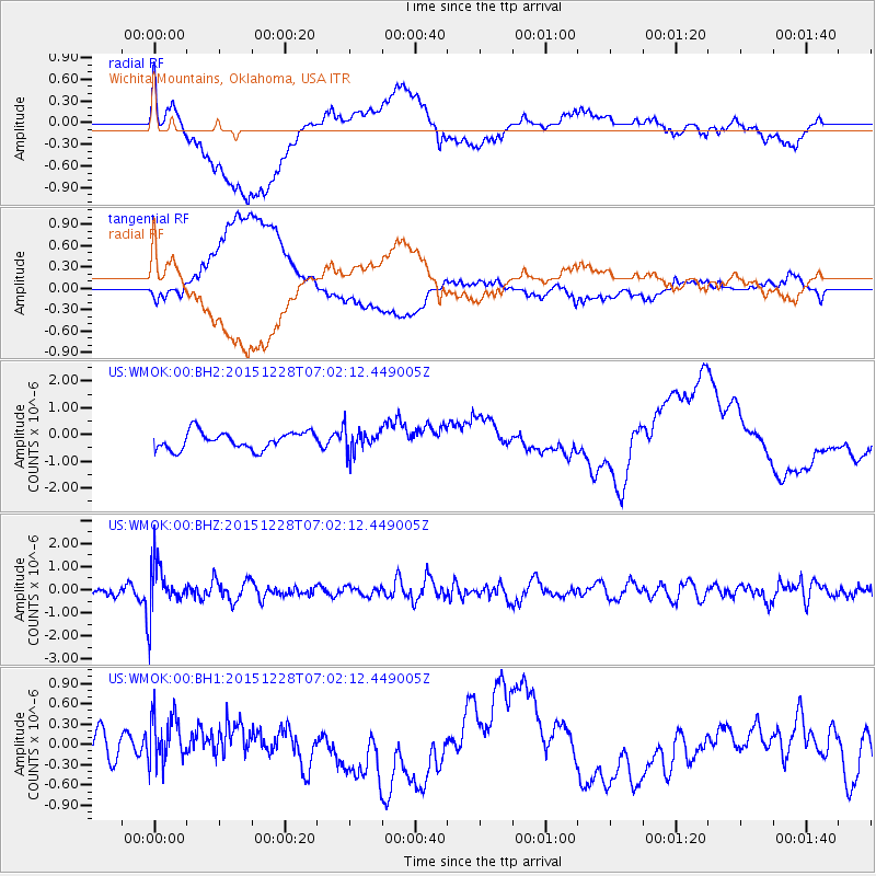
WMOK Wichita Mountains, Oklahoma, USA - Earthquake Result Viewer
*The percent match for this event was below the threshold and hence no stack was calculated.
| Earthquake location: |
Windward Islands |
| Earthquake latitude/longitude: |
14.6/-61.4 |
| Earthquake time(UTC): |
2015/12/28 (362) 06:55:30 GMT |
| Earthquake Depth: |
153 km |
| Earthquake Magnitude: |
5.6 MWP |
| Earthquake Catalog/Contributor: |
NEIC PDE/NEIC COMCAT |
|
| Network: |
US United States National Seismic Network |
| Station: |
WMOK Wichita Mountains, Oklahoma, USA |
| Lat/Lon: |
34.74 N/98.78 W |
| Elevation: |
486 m |
|
| Distance: |
39.2 deg |
| Az: |
307.606 deg |
| Baz: |
111.359 deg |
| Ray Param: |
$rayparam |
*The percent match for this event was below the threshold and hence was not used in the summary stack. |
|
| Radial Match: |
53.61235 % |
| Radial Bump: |
400 |
| Transverse Match: |
49.617928 % |
| Transverse Bump: |
400 |
| SOD ConfigId: |
1259291 |
| Insert Time: |
2016-01-11 07:38:44.642 +0000 |
| GWidth: |
2.5 |
| Max Bumps: |
400 |
| Tol: |
0.001 |
|
Signal To Noise
| Channel | StoN | STA | LTA |
| US:WMOK:00:BHZ:20151228T07:02:12.449005Z | 3.7804933 | 1.0538799E-6 | 2.7876786E-7 |
| US:WMOK:00:BH1:20151228T07:02:12.449005Z | 1.5454785 | 3.8838633E-7 | 2.513049E-7 |
| US:WMOK:00:BH2:20151228T07:02:12.449005Z | 1.3796366 | 4.4982846E-7 | 3.260485E-7 |
| Arrivals |
| Ps | |
| PpPs | |
| PsPs/PpSs | |


