You are here: Home > Network List > TA - USArray Transportable Network (new EarthScope stations) Stations List
> Station L19A Farson, WY, USA > Earthquake Result Viewer
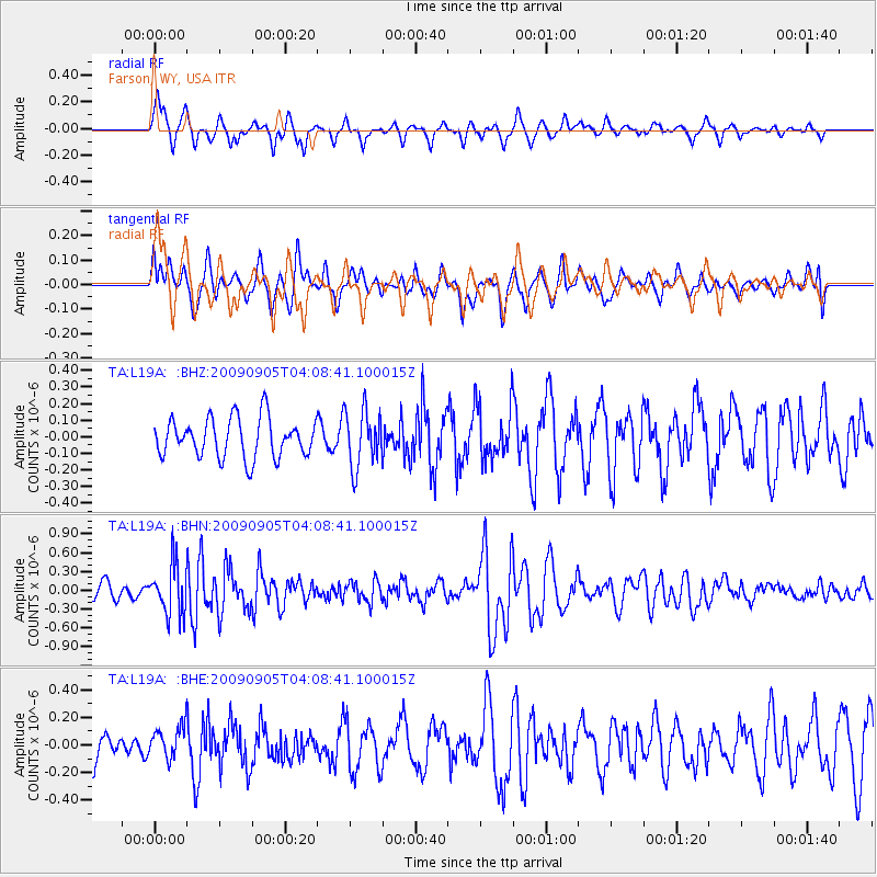
L19A Farson, WY, USA - Earthquake Result Viewer
*The percent match for this event was below the threshold and hence no stack was calculated.
| Earthquake location: |
Southern Peru |
| Earthquake latitude/longitude: |
-15.1/-70.2 |
| Earthquake time(UTC): |
2009/09/05 (248) 03:58:39 GMT |
| Earthquake Depth: |
210 km |
| Earthquake Magnitude: |
5.8 MW, 5.2 MB, 5.8 MW |
| Earthquake Catalog/Contributor: |
WHDF/NEIC |
|
| Network: |
TA USArray Transportable Network (new EarthScope stations) |
| Station: |
L19A Farson, WY, USA |
| Lat/Lon: |
42.10 N/109.36 W |
| Elevation: |
2034 m |
|
| Distance: |
67.4 deg |
| Az: |
329.433 deg |
| Baz: |
138.701 deg |
| Ray Param: |
$rayparam |
*The percent match for this event was below the threshold and hence was not used in the summary stack. |
|
| Radial Match: |
63.33617 % |
| Radial Bump: |
356 |
| Transverse Match: |
57.21952 % |
| Transverse Bump: |
400 |
| SOD ConfigId: |
2622 |
| Insert Time: |
2010-03-06 00:50:01.256 +0000 |
| GWidth: |
2.5 |
| Max Bumps: |
400 |
| Tol: |
0.001 |
|
Signal To Noise
| Channel | StoN | STA | LTA |
| TA:L19A: :BHN:20090905T04:08:41.100015Z | 2.260211 | 3.9865046E-7 | 1.7637754E-7 |
| TA:L19A: :BHE:20090905T04:08:41.100015Z | 0.6168096 | 1.1623345E-7 | 1.88443E-7 |
| TA:L19A: :BHZ:20090905T04:08:41.100015Z | 1.4638267 | 1.7194189E-7 | 1.1746055E-7 |
| Arrivals |
| Ps | |
| PpPs | |
| PsPs/PpSs | |


