You are here: Home > Network List > TA - USArray Transportable Network (new EarthScope stations) Stations List
> Station L19A Farson, WY, USA > Earthquake Result Viewer
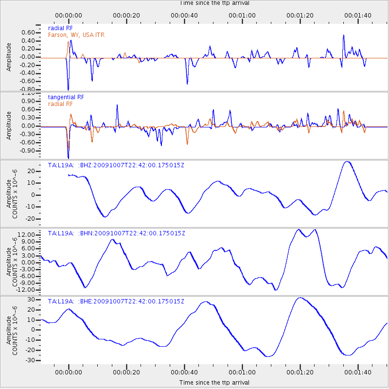
L19A Farson, WY, USA - Earthquake Result Viewer
*The percent match for this event was below the threshold and hence no stack was calculated.
| Earthquake location: |
Santa Cruz Islands |
| Earthquake latitude/longitude: |
-11.5/166.0 |
| Earthquake time(UTC): |
2009/10/07 (280) 22:29:18 GMT |
| Earthquake Depth: |
35 km |
| Earthquake Magnitude: |
5.5 MB |
| Earthquake Catalog/Contributor: |
WHDF/NEIC |
|
| Network: |
TA USArray Transportable Network (new EarthScope stations) |
| Station: |
L19A Farson, WY, USA |
| Lat/Lon: |
42.10 N/109.36 W |
| Elevation: |
2034 m |
|
| Distance: |
93.7 deg |
| Az: |
47.939 deg |
| Baz: |
257.913 deg |
| Ray Param: |
$rayparam |
*The percent match for this event was below the threshold and hence was not used in the summary stack. |
|
| Radial Match: |
51.69213 % |
| Radial Bump: |
351 |
| Transverse Match: |
69.61298 % |
| Transverse Bump: |
202 |
| SOD ConfigId: |
2622 |
| Insert Time: |
2010-03-06 00:50:08.027 +0000 |
| GWidth: |
2.5 |
| Max Bumps: |
400 |
| Tol: |
0.001 |
|
Signal To Noise
| Channel | StoN | STA | LTA |
| TA:L19A: :BHN:20091007T22:42:00.175015Z | 1.141903 | 4.8645443E-6 | 4.2600327E-6 |
| TA:L19A: :BHE:20091007T22:42:00.175015Z | 2.7875686 | 1.9804975E-5 | 7.104749E-6 |
| TA:L19A: :BHZ:20091007T22:42:00.175015Z | 0.32268637 | 3.7668597E-6 | 1.1673439E-5 |
| Arrivals |
| Ps | |
| PpPs | |
| PsPs/PpSs | |


