You are here: Home > Network List > TA - USArray Transportable Network (new EarthScope stations) Stations List
> Station L19A Farson, WY, USA > Earthquake Result Viewer
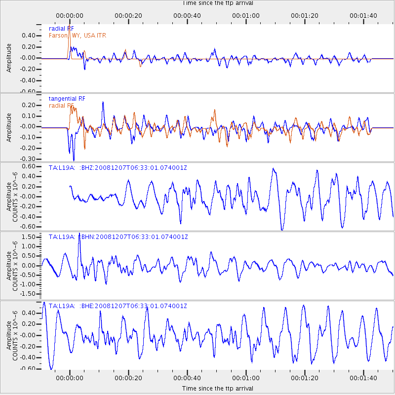
L19A Farson, WY, USA - Earthquake Result Viewer
*The percent match for this event was below the threshold and hence no stack was calculated.
| Earthquake location: |
Northern Mid-Atlantic Ridge |
| Earthquake latitude/longitude: |
13.4/-44.8 |
| Earthquake time(UTC): |
2008/12/07 (342) 06:23:09 GMT |
| Earthquake Depth: |
10 km |
| Earthquake Magnitude: |
5.6 MB, 5.3 MS, 5.7 MW |
| Earthquake Catalog/Contributor: |
WHDF/NEIC |
|
| Network: |
TA USArray Transportable Network (new EarthScope stations) |
| Station: |
L19A Farson, WY, USA |
| Lat/Lon: |
42.10 N/109.36 W |
| Elevation: |
2034 m |
|
| Distance: |
62.3 deg |
| Az: |
310.642 deg |
| Baz: |
97.06 deg |
| Ray Param: |
$rayparam |
*The percent match for this event was below the threshold and hence was not used in the summary stack. |
|
| Radial Match: |
57.488235 % |
| Radial Bump: |
400 |
| Transverse Match: |
69.41124 % |
| Transverse Bump: |
331 |
| SOD ConfigId: |
2658 |
| Insert Time: |
2010-03-06 00:50:23.733 +0000 |
| GWidth: |
2.5 |
| Max Bumps: |
400 |
| Tol: |
0.001 |
|
Signal To Noise
| Channel | StoN | STA | LTA |
| TA:L19A: :BHN:20081207T06:33:01.074001Z | 2.3332078 | 6.429686E-7 | 2.755728E-7 |
| TA:L19A: :BHE:20081207T06:33:01.074001Z | 0.58212686 | 1.6865398E-7 | 2.8972033E-7 |
| TA:L19A: :BHZ:20081207T06:33:01.074001Z | 1.5573605 | 1.7297069E-7 | 1.1106657E-7 |
| Arrivals |
| Ps | |
| PpPs | |
| PsPs/PpSs | |


