You are here: Home > Network List > TA - USArray Transportable Network (new EarthScope stations) Stations List
> Station L19A Farson, WY, USA > Earthquake Result Viewer
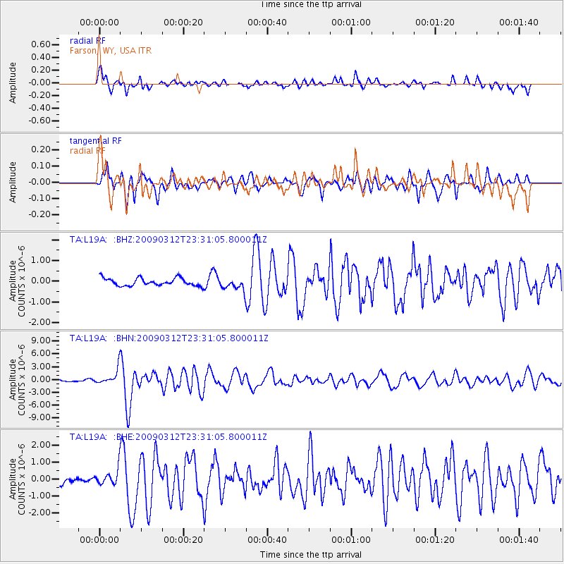
L19A Farson, WY, USA - Earthquake Result Viewer
*The percent match for this event was below the threshold and hence no stack was calculated.
| Earthquake location: |
South Of Panama |
| Earthquake latitude/longitude: |
5.7/-82.8 |
| Earthquake time(UTC): |
2009/03/12 (071) 23:23:34 GMT |
| Earthquake Depth: |
9.0 km |
| Earthquake Magnitude: |
6.1 MB, 5.9 MS, 6.3 MW, 6.2 MW |
| Earthquake Catalog/Contributor: |
WHDF/NEIC |
|
| Network: |
TA USArray Transportable Network (new EarthScope stations) |
| Station: |
L19A Farson, WY, USA |
| Lat/Lon: |
42.10 N/109.36 W |
| Elevation: |
2034 m |
|
| Distance: |
43.3 deg |
| Az: |
330.93 deg |
| Baz: |
139.48 deg |
| Ray Param: |
$rayparam |
*The percent match for this event was below the threshold and hence was not used in the summary stack. |
|
| Radial Match: |
72.93036 % |
| Radial Bump: |
400 |
| Transverse Match: |
69.18016 % |
| Transverse Bump: |
400 |
| SOD ConfigId: |
2658 |
| Insert Time: |
2010-03-06 00:50:28.766 +0000 |
| GWidth: |
2.5 |
| Max Bumps: |
400 |
| Tol: |
0.001 |
|
Signal To Noise
| Channel | StoN | STA | LTA |
| TA:L19A: :BHN:20090312T23:31:05.800011Z | 6.97374 | 1.9388067E-6 | 2.7801534E-7 |
| TA:L19A: :BHE:20090312T23:31:05.800011Z | 1.7586246 | 5.0497135E-7 | 2.8713993E-7 |
| TA:L19A: :BHZ:20090312T23:31:05.800011Z | 1.6970028 | 3.0981644E-7 | 1.8256686E-7 |
| Arrivals |
| Ps | |
| PpPs | |
| PsPs/PpSs | |


