You are here: Home > Network List > TA - USArray Transportable Network (new EarthScope stations) Stations List
> Station E23K Chandalar, AK, USA > Earthquake Result Viewer
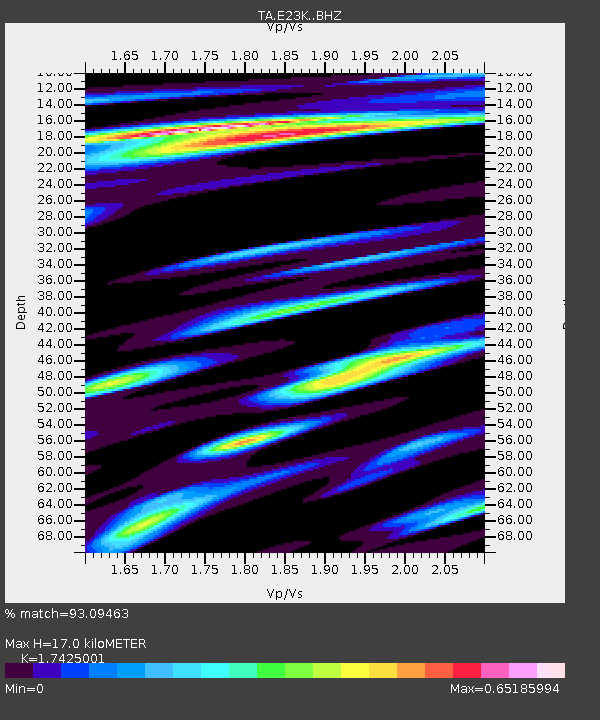
E23K Chandalar, AK, USA - Earthquake Result Viewer
| Earthquake location: |
Near Coast Of Chiapas, Mexico |
| Earthquake latitude/longitude: |
14.2/-93.2 |
| Earthquake time(UTC): |
2017/06/14 (165) 06:38:48 GMT |
| Earthquake Depth: |
11 km |
| Earthquake Magnitude: |
5.5 Mww |
| Earthquake Catalog/Contributor: |
NEIC PDE/us |
|
| Network: |
TA USArray Transportable Network (new EarthScope stations) |
| Station: |
E23K Chandalar, AK, USA |
| Lat/Lon: |
68.06 N/149.62 W |
| Elevation: |
1084 m |
|
| Distance: |
64.7 deg |
| Az: |
339.723 deg |
| Baz: |
116.594 deg |
| Ray Param: |
0.058763027 |
| Estimated Moho Depth: |
17.0 km |
| Estimated Crust Vp/Vs: |
1.74 |
| Assumed Crust Vp: |
6.316 km/s |
| Estimated Crust Vs: |
3.625 km/s |
| Estimated Crust Poisson's Ratio: |
0.25 |
|
| Radial Match: |
93.09463 % |
| Radial Bump: |
400 |
| Transverse Match: |
81.919075 % |
| Transverse Bump: |
400 |
| SOD ConfigId: |
13570011 |
| Insert Time: |
2019-04-28 04:57:58.842 +0000 |
| GWidth: |
2.5 |
| Max Bumps: |
400 |
| Tol: |
0.001 |
|

Signal To Noise
| Channel | StoN | STA | LTA |
| TA:E23K: :BHZ:20170614T06:48:55.54999Z | 7.3427367 | 5.123854E-7 | 6.978126E-8 |
| TA:E23K: :BHN:20170614T06:48:55.54999Z | 2.112118 | 6.2889704E-8 | 2.977566E-8 |
| TA:E23K: :BHE:20170614T06:48:55.54999Z | 5.4348416 | 1.8458931E-7 | 3.3964064E-8 |
| Arrivals |
| Ps | 2.1 SECOND |
| PpPs | 7.1 SECOND |
| PsPs/PpSs | 9.2 SECOND |


